California’s Central Valley is an agricultural bonanza, producing a third of America’s food crops. But it’s facing serious water challenges.
The valley floor is 20,000 sq miles of some of the most fertile soil on Earth. Here, the sun shines 300 days a year. More than 250 different crops grow, worth $17 billion per year.
The valley was developed into farmland around the turn of the twentieth century. When farmers arrived, they began to drill wells into the fresh-water aquifers below.
By the 1930s, scientists began to notice an impact. Some of the aquifers, with their water levels and pressure drawn down, compacted. This meant they would never refill to earlier levels, and the land above them subsided.
This continued into the 1970s, when sinking land, up to 30 ft in parts of the valley, had damaged roads, bridges, and buildings so dramatically that California spent millions to repair them and built canals to bring in water.
The problem was alleviated—until conservation elsewhere in the state reduced water in the canals and valley farmers pulled hard on their wells again.
The wells remained unregulated until 2012, when California passed serious water legislation. It will be decades before it’s fully phased in, but the hardest-hit areas are being addressed now.
In the meantime, the valley floor and the water table continue to fall.
Background
Synopsis: If you ate a salad today, you probably enjoyed produce from the Central Valley of California. One of the seven most fertile valleys in the world, it provides more than a third of the produce grown in the United States. But overpumping of groundwater for irrigation has not just caused aquifer water levels to drop—the valley floor is subsiding up to inches per month during drought periods in some areas, threatening critical infrastructure.
- The Central Valley covers more than 20,000 sq miles, around 15 million acres, making the area larger than nine of our U.S. states.
- The Central Valley, about 450 miles long and up to 60 miles wide, is completely surrounded by mountains. The northern third is known as the Sacramento Valley, and the southern two-thirds are known as the San Joaquin Valley.
- It is remarkably flat, having been filled over the millennia by more than 25,000 ft of sediment from surrounding mountain watersheds.
- The temperature range is perfect for plants, and the sun shines nearly 300 days a year. It is one of the world’s most fertile valleys, with some of the best-quality soil in the world. More than 250 different crops, worth more than $17 billion per year, are currently grown in the valley.
- Subterranean aquifers in the Central Valley extend for more than 400 miles.
- Deeper confined aquifers contain ancient water that is 10,000–20,000 years old, while shallower unconfined aquifers can be recharged by surface-water percolation.
- Today, the aquifers in the Central Valley supply about 20% of the groundwater in the United States and are essential to our domestic food-production industry.
- Researchers believe that since pumping started nearly a century ago, the aquifers have produced more than 125 million acre-feet of groundwater, about 4-1/2 times the volume of Lake Mead, the largest reservoir in the U.S.
- An acre-foot is the volume of 1 ft of water over an acre in area and equals about 326,000 gallons, half the volume of an Olympic swimming pool.
- The Central Valley has a rich human history.
- Spaniards settled it the 1700s, followed by Mexicans, Americans, Asians, and Europeans in the 1800s.
- Early trappers and settlers described miles and miles of grasses and wetlands, as well as a large inland lake that no longer exists.
- With difficult times caused by the Depression and Dust Bowl in the 1920s and 1930s, farmers immigrated from the eastern and central United States as well as Europe, lured by the cheap land and plentiful water.
- Central Valley farmers have used groundwater for more than a century, and by the 1930s, scientists could already see that the land surface was dropping.
- In the 1940s, hydrologist Joseph Poland discovered that in the areas underneath the sinking land, groundwater was being pumped rapidly to irrigate crops.
- In the 1970s, after about 50 years of pumping, groundwater levels declined and ground subsidence of at least a foot over an area of 5,200 sq miles occurred; by 1977, the land had subsided nearly 30 ft in some places.
- What caused the ground to subside?
- Sand grains and gravels form framework-supported sediments with 3D pore networks that water can flow through, but finer-grained silt and clay units consist of smaller or platier grains that can limit flow rates.
- Sandier units retain their framework and compact less than clay units when water is removed. They also recharge more easily when water is replenished in their recharge area.
- When finer-grained clay units compact, they may change structure and compact irreversibly (see figure at right). Consequently, aquifer water storage previously available in these units may be lost forever, resulting in permanent ground subsidence.
- Since 1955, the subsidence has caused more than $1.3 billion in damages to highways, bridges, and canals.
- To relieve the need to use groundwater, California built enormous canal systems to move water from areas to the north with more plentiful water to the Central Valley; finally, the subsidence slowed.
- During several droughts since the mid-1970s, surface water was less available, and increased pumping necessary for irrigation dropped water levels to new lows.
- The amount of subsidence observed recently has stunned scientists.
- During the 2007–2009 drought alone, InSAR (Interferometric Synthetic Aperture Radar) satellite data suggest that the ground surface sank nearly 3 ft in some areas.
- From 2013 to 2016, drought conditions again resulted in overpumping, which InSAR satellite data show may have caused up to 28 more inches of subsidence, with 18 inches of that occurring in just 3 months in 2016—coming very close to essential aqueducts and canals.
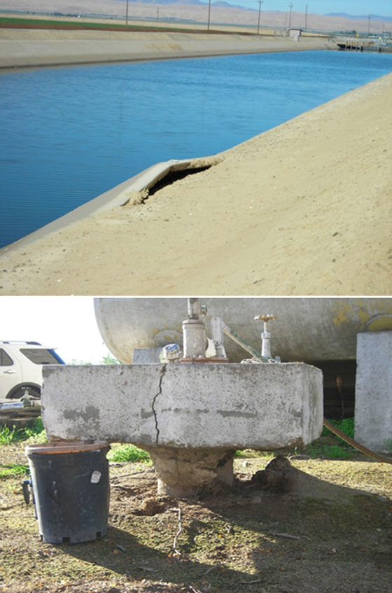
- The subsidence is so broad, it is hard to see even if you are standing in the middle of it —the depression it has created is larger than the state of Connecticut. But you can see the effects of the subsidence in the recent damage it has caused.
- Bridges have been sinking to the point they are nearly submerged and will have to be rebuilt.
- Schools and other structures are at risk of flooding because they now sit in low spots.
- Canal systems are in jeopardy because their dams are sinking, lowering their water levels.
- Canals, railroads, and highways are cracking as the ground supporting them shifts unevenly.
- Wells for both irrigation and public drinking water are emerging from the ground, and well casings that form the “drinking straws” that suck water from the earth are buckling as the earth subsides around them.
- Today, more than 100,000 wells produce water from the Central Valley aquifers; most are unmonitored and, therefore, unregulated. More attention needs to be paid to water sustainability.
- When researchers compare the amount of water needed for agriculture to the amount of water currently available in the aquifers and from the canal system, it is obvious that some areas could struggle to meet the demand required to produce their crops at the current level.
- Recent snowpack and rains have provided recharge, but aquifers that have lost storage capacity will never regain their original capability to hold water.
- California groundwater legislation has finally been enacted as a phased approach, focusing on severe areas first, but is not yet in effect.
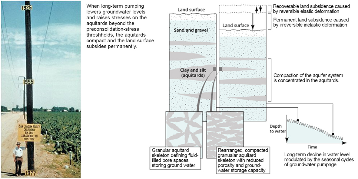
Right: Land subsidence cause and effect. Credit: Land Subsidence: Cause & Effect | USGS