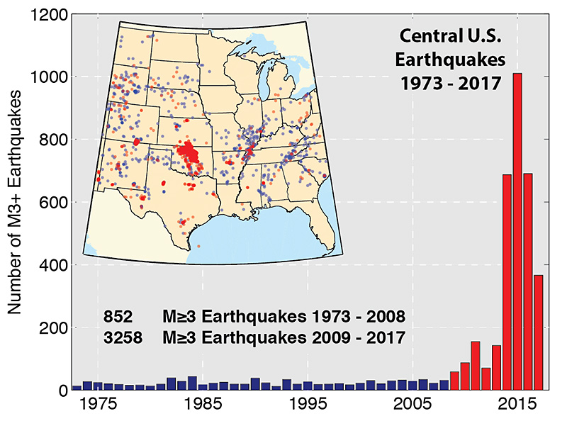
Cumulative number of earthquakes with a magnitude of 3.0 or larger in the central and eastern United States, 1970–2016. The long-term rate of approximately 29 earthquakes per year increased sharply starting around 2009.
Credit: U.S. Geological Survey (public domain)
A decade ago, there were typically 20 earthquakes a year that were large enough to feel in the central and eastern U.S. But in 2015, there were over 1,000 of them.
Why? It’s mostly because we’re pumping more water into the ground.
The boom in U.S. oil and gas production over the last decade has brought many more oil wells —which also produce water.
Most is naturally occurring in the formation and some was injected by operators to allow or improve the recovery of oil and gas.
In both cases, the water will likely have picked up salt and other minerals from the rock, making it many times saltier than seawater.
Operators may reinject this water to continue to liberate oil and gas.
But more often, there’s too much to handle. So it’s trucked or piped to disposal wells, where it’s pumped down into deep saltwater reservoirs.
Adding large volumes of wastewater increases the pressure in these rock formations—which can allow natural faults to slip more easily than they normally would, causing earthquakes.
To address these quakes, regulators and the petroleum industry are monitoring disposal wells and shutting down those that could cause damaging seismic activity. And they now think that managing wastewater injection more carefully should help.
There’s still more work to be done, and university research centers like the Bureau of Economic Geology are conducting major studies, with the aim of minimizing the risk of earthquakes while maintaining the benefits of domestic energy production.
Background
Synopsis: Since 2009, earthquake activity in the shallow crust has increased in the central and eastern United States, with much of the change being attributed to increased fluid-injection activities related to oil and gas development. Seismometers have been deployed in the region to improve our ability to detect and locate earthquakes. What can we do to manage the risk of injection-related seismicity?
A previous episode of EarthDate (052: Human-Induced Earthquakes) talks about how human activity such as extracting material from and injecting fluids into the earth, loading the surface of Earth, and setting off bombs underground can perturb the delicate balance of faults and stress in the earth and cause earthquakes.
Since the beginning of the Industrial Revolution, humans have produced products that make our lives easier but also generate solid and liquid waste requiring treatment or disposal.
In the past, wastewater from industrial processes was sometimes dumped into rivers, with terrible consequences for downstream locations.
Today, when large volumes of waste fluids are generated, the preferred method of disposal is often injection into deep geologic rock units well below the levels of our freshwater aquifers. This activity is regulated and monitored by government agencies.
In the past decade, the south-central United States has seen a large increase in the production of wastewater related to accelerated oil and gas development in the United States. Utilization of disposal wells and volumes requiring injection have thus increased dramatically.
All conventional oil and gas wells produce some wastewater.
Enhanced oil recovery uses fluids like water to flush remaining oil out of older conventional reservoirs.
Some wells produce more than 90 percent saline water and contaminants, which are usually recycled back into the producing reservoir, helping push out the remaining oil and saving operators the cost of transportation and disposal.
Unconventional reservoirs are characterized by low porosity and permeability. To get oil and gas out of these rocks, drillers install horizontal wells and use pressurized water, chemicals, and sand to create cracks in them.
This practice, known as hydraulic fracturing (aka hydrofracturing, fracking), has been used for many decades. Its popularity skyrocketed with the recent unconventional reservoir boom.
Thousands of micro-earthquakes are induced during the process of hydraulic fracturing; they are localized around the wellbore and have very low magnitudes (ranging from -3 to 0) so are not felt at the surface.
In very rare instances, hydraulic fracturing has induced larger earthquakes, some as large as magnitude 4.
In Oklahoma, where 70 percent of recent earthquakes in the central and eastern U.S. have occurred, most water injected for disposal comes from conventional oil and gas wells that produced large quantities of water; less than 1 percent comes from hydraulic-fracturing flowback.
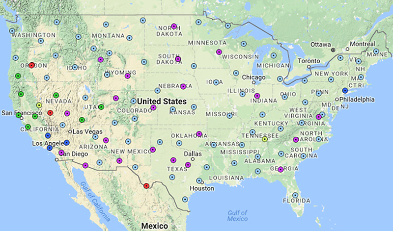
The USGS Reference Station Network forms the backbone of the lower 48 United States seismic array.
Credit: EarthScope
Earth is stressed by tectonic forces. Faults, natural breaks in Earth’s crust, are everywhere.
Earthquakes infrequently occur as a natural geologic process throughout relatively stable continental areas.
Earthquakes can be triggered by fluid injection when the change in pressure is sufficient to overcome the resistance to slip along preexisting, prestressed faults. The balance of stress acting on faults can be upset by injecting wastewater, which increases fluid pressure, triggering earthquakes and releasing energy that is already stored in the rock.
If subsurface pathways like highly permeable formations and faults exist, the increase in fluid pressure from injected water can travel surprisingly far and fast from the point of injection through rock layers.
Injection-related seismicity has been documented as much as 56 miles (90 km) away from the site of injection.
In general, people tend to feel earthquakes at the surface with magnitude 3 or greater. The underlying geology impacts how strongly earthquakes shake the surface.
From 1970 through 2000, an average of 20 earthquakes per year with a magnitude greater than 3 occurred in the U.S. Midcontinent.
But from 2010 to 2013, earthquake activity at that magnitude jumped to about 100 per year; and more than 600 earthquakes occurred each year from 2014 to 2016. Nearly 1000 earthquakes of magnitude 3 or more occurred in 2015 alone.
Increased seismic-monitoring infrastructure has improved detection of earthquakes.
Out of more than 30,000 disposal wells in the region, very few appear to have triggered earthquakes.
Recent research shows that less than 1.5 percent of disposal wells and 0.5 percent of hydrofracturing wells appear to have had seismicity associated with them in Ohio and Canada.
The largest earthquake in the region impacted by wastewater injection had a magnitude of 5.8 and took place in Pawnee, Oklahoma, in September 2016.
People in states from Tennessee to Arizona felt the tremors.
Oklahoma’s governor declared a state of emergency, and the Oklahoma Corporation Commission ordered nearby disposal wells shut down.
Limitations were placed on the depth and volume of injected wastewater in the state.
The first step toward managing injection-related earthquakes is to avoid injection near potentially problematic faults.
In most areas, information from existing wells in a region can be used to assess the stress state in a given area.
Faults can be mapped using direct surface observation and/or remote subsurface data.
By combining information about the state of stress and preexisting faults, the likelihood that pressure changes can induce seismicity can be assessed.
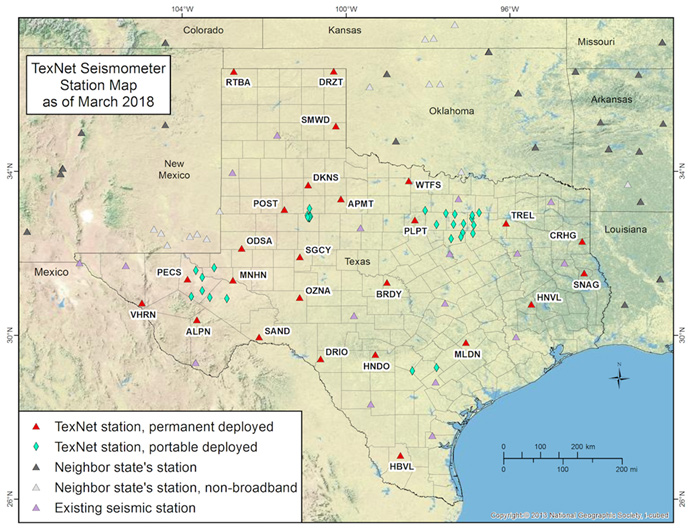
The TexNet Seismic Monitoring Program has permanent and portable stations distributed around Texas. Credit: The University of Texas at Austin, BEG Center for Integrated Seismicity Research TexNet Earthquake CatalogMethods of reducing the risk of seismicity in existing disposal wells include the following:
Decreasing and balancing injection volumes, rates, and times in existing wells to reduce fluid pressures underground
Avoiding injection into formations that occur just above igneous and metamorphic basement. Faults in these units are likely to be larger and the stresses in the basement are typically higher.
Recycling produced water from oil and gas wells back into the formation it came from to manage pressure
Possibly recycling water that flows back from hydrofracturing for use in future fracking (such water may require treatment)
Implementing “traffic-light systems” such as those used by regulatory agencies in some U.S. states and Canadian provinces to monitor hydrofracturing activities. Green means everything is stable and operations can proceed according to plan; yellow means minor issues have been noted but proceed with caution or with an amended plan; and red means stop operations immediately.
Seismic monitoring is crucial for knowing exactly where and how earthquakes occur, whether they might be related to oil and gas activities, and which measures to take to minimize surface impact of earthquakes.
The U.S. Geological Survey (USGS) constantly monitors earthquakes across the United States using multiple arrays of seismometers, including permanent and portable stations.
Some states, like Texas, have increased the number of stations they use to help triangulate the locations of any earthquakes. Texas now has over 60 stations in its TexNet network, managed by the Bureau of Economic Geology (BEG).