Credit: David Rydevik, Stockholm, Sweden, via Wikimedia Commons (public domain).
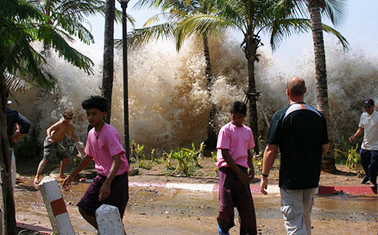
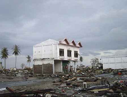
The day after Christmas in 2004, a tsunami swept over Indonesia, Thailand, and 12 other countries. It killed more than 230,000 people in the most lethal natural disaster in recorded history.
Most of us remember the news footage from those grim days. What you may not remember is that the tsunami was caused by an earthquake. Scientists now know it was the most powerful earthquake in 40 years, a 9.3 on the Richter scale. Its epicenter was below the ocean floor, about 100 miles west of Sumatra.
The quake had the longest duration ever recorded, about 10 minutes of continuous motion as Earth’s crust ripped to form a 50-foot cliff on the seafloor. The tear continued moving north for almost an hour, finally extending more than 750 miles.
It was the huge volume of water displaced by this movement that caused the tsunami.
The quake shook the ground everywhere on Earth and triggered powerful aftershocks and earthquakes as far away as Alaska. The entire planet vibrated for weeks.
GPS data showed changes in the surface of most of the Eastern Hemisphere. Masses inside Earth shifted, which moved the location of the North Pole by an inch. Even the shape of the globe changed—very slightly, but enough to increase its rotational speed and shorten the length of the day by 3 microseconds.
December 26, 2004, was a shocking day in Earth’s history, for humans and the planet itself.
Background
Credit: Michael L. Bak, via Wikimedia Commons (public domain).
Synopsis: The Sumatra–Andaman earthquake was the third-largest earthquake ever recorded on a seismograph. It had the longest duration ever recorded, with 8.3–10 min of continuous motion along the 1,255-km fault scarp.
- The 2004 Indian Ocean earthquake occurred at 00:58:53 UTC on 26 December (7:58:53 local time), with the epicenter off the west coast of Sumatra, Indonesia.
- The undersea megathrust earthquake was caused when the Indian Plate was subducted under the Burma Plate.
- The earthquake was the third-largest ever recorded on a seismograph, and the most powerful quake on the globe in 40 years. The shock had a moment magnitude of 9.1–9.3 and a maximum Mercalli intensity of IX (Violent).
- The epicenter was located about 150 km (93 miles) off the west coast of Sumatra.
- The earthquake triggered a tsunami that killed more than 230,000 people, more than any natural catastrophe in history, inundating coastal communities with waves up to 30 m (100 ft) high.
- The disaster killed people in more than 14 countries, as far away as South Africa.
- The fault had been storing up energy for more than 700 years, since an earthquake that occurred between AD 1300 and 1400.
- The quake had the longest duration ever observed near the epicenter, with continuous motion along the fault for 8.3 to 10 min; most earthquakes last only a few seconds.
- The sea withdrew for more than 5 min. before the devastating waves returned.
- The earthquake shook the ground everywhere on Earth’s surface and caused the entire planet to vibrate as much as 1 cm (0.4 inches); weeks later the planet was still reverberating.
- The earthquake produced measurable deformations in Earth's crust—as recorded in GPS data—over nearly an entire hemisphere.
- Changes in the distribution of masses inside the Earth due to the earthquake had severe consequences:
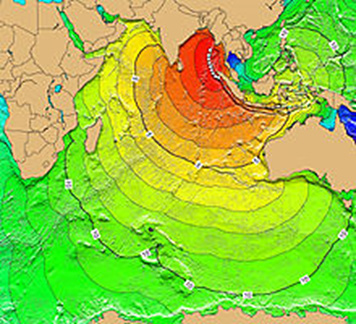
Tsunami travel time (TTT) map for 2004 Indian Ocean tsunami indicating first-arrival travel times of 2004 tsunami, following their generation at earthquake epicenter in 1-hr intervals.
Credit: NOAA National Center for Environmental Information via Wikimedia Commons.- It displaced the North Pole by 2.5 cm.
- It also changed slightly the shape of Earth; more specifically, it decreased Earth's oblateness by about one part in 10 billion, consequentially increasing Earth's rotation a little and thus shortening the length of the day by 2.68 microseconds.
- The earthquake produced the longest fault rupture ever observed, 1255 km (780 miles), the distance from LA to Portland.
- The fault moved 15–20 m and progressed from south to north along the curved plate boundary. The rupture progressed rapidly at first, producing displacements of up to 20 m (60 ft), then continued more slowly farther north.
- The rupture itself took about 1 hr, moving mostly from south to north; the GPS data indicate some additional deformation after that.
- Seismic waves from the Sumatra–Andaman earthquake also triggered other earthquakes in distant areas like Alaska.
- The megathrust earthquake was followed by several other aftershocks, some of which had magnitudes as high as 6.1.
- The Indian Ocean tsunami warning system was formed in early 2005 immediately after the tragedy of 26 December 2004 to provide an early warning of tsunamis for inhabitants around the Indian Ocean coasts.