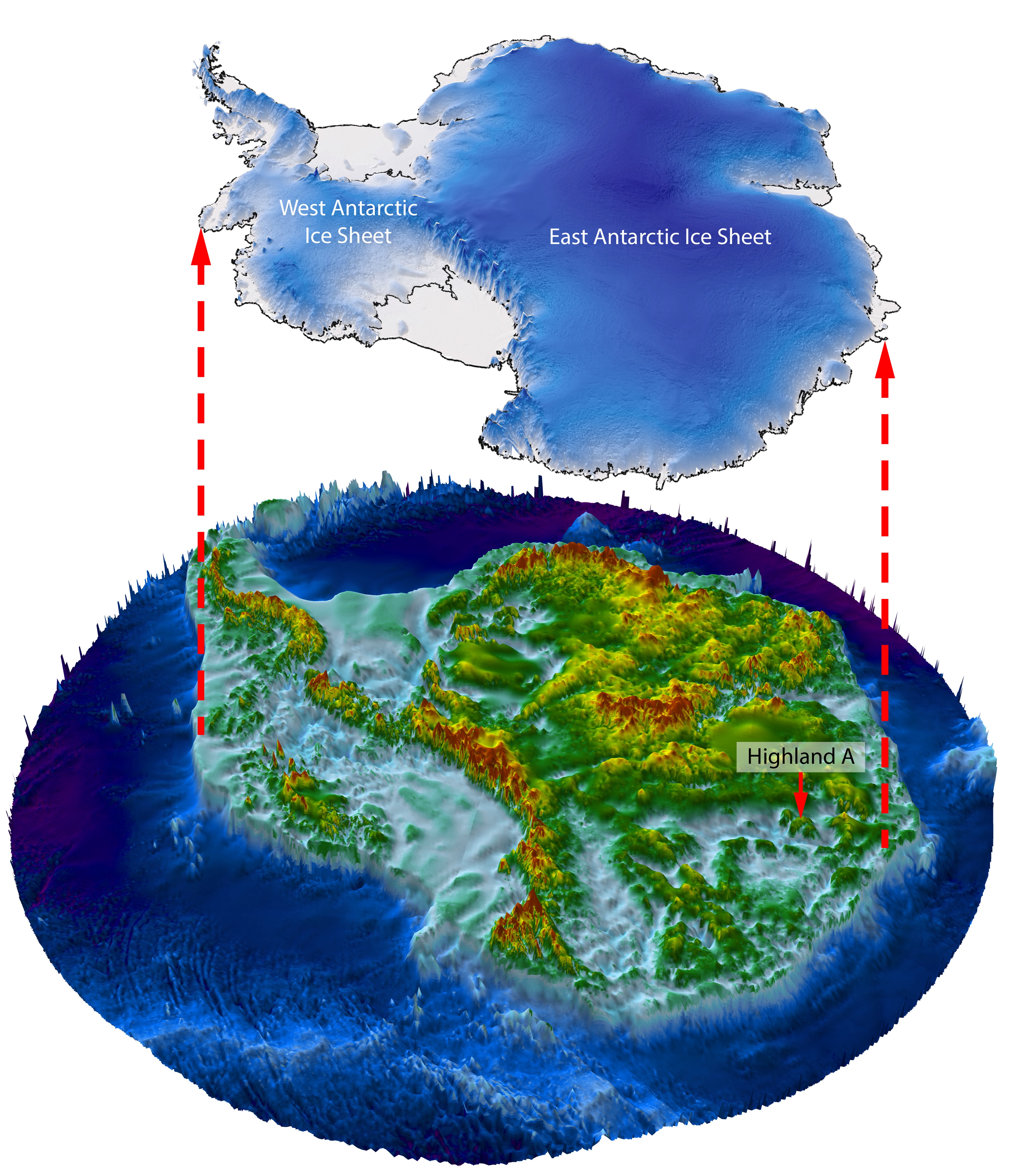
Credit: Stewart Jamieson/Durham University
Antarctica is a continent of extremes and superlatives.
It’s the coldest continent, with Earth’s lowest recorded temperature of 130 below zero Fahrenheit.
It’s the driest continent, with just 6 inches of precipitation a year.
It’s the windiest continent, with gusts up to 200 miles an hour.
Surprisingly, it’s the highest continent, with an average altitude of 8,200 feet, largely due to ice sheets up to 15,000 feet thick.
It also has an extreme range of geologic age, with rocks nearly 4 billion years old on one end, and young volcanoes forming on the other.
Hundreds of millions of years ago, Antarctica sat within the supercontinent of Pangea. When Pangea began to break up, more than 80 million years ago, Antarctica ended up alone at the southern end of the Earth.
When the climate cooled 34 million years ago, Antarctica began to ice over. Over millions more years, as glaciers advanced and retreated on Earth dozens of times, ice built steadily on Antarctica, such that 98% of its land is now covered in ice, hiding what lies below.
As a result, we know less about Antarctica’s geology than that of the Moon or Mars.
But with advanced satellite sensing, scientists are now able to look below the ice, to map a continent of massive bluffs, erosion zones and ancient river drainages that still shape the flow of ice today.
Background
Synopsis: With 98% of its surface covered by ice, Antarctica may look simple on a world map but, just like Earth’s other continents, it has a long and complex geological history. Its oldest rocks are more than 3.8 billion years old, and its youngest rocks are modern volcanics. To sort out the geology lurking below the ice, geological detectives use sparse outcrops, aerial and satellite-based remote sensing, and geological plate reconstructions.
- While the Antarctic Circle was first crossed by Captain James Cook in 1773, the first sighting of Antarctica didn’t occur until 200 years ago with competing claims by Russia and Britain in January of 1820.
- In a previous EarthDate episode (ED-142 Tragedy on Ice), we talked about some of the tragic early exploration efforts on the continent in the early 1900s by the Scott and Amundsen parties.
- On December 1, 1959 twelve countries (Argentina, Australia, Belgium, Chile, France, Japan, New Zealand, Norway, South Africa, the Soviet Union, the United Kingdom, and the United States) signed the Antarctic Treaty prohibiting military activity and setting aside the entire continent as a scientific preserve. The treaty has now been signed by an additional 45 countries for a total of 57 parties.
- Antarctica is a remarkable and mysterious continent with an areal extent about one and a half times the land area of all 50 of the United States.
- With ice sheets more than 3 mi (5 km) thick that have been accumulating for more than 34 million years, it is Earth’s coldest continent, with Earth’s coldest ever temperature of -128.6°F (-89.2°C) recorded at Vostok Station in July 1983.
- It is the driest continent, receiving an average of just 6.5 in (16.5 cm) of precipitation per year.
- It is the windiest continent with a wind speed of 199 mph (320 km/h) recorded at Dumont d’Urville Station in July 1972.
- It is the highest continent, with its elevation averaging 8200 ft (2500 m), more than three times the average elevation of the United States of 2500 ft (762 m).
- Antarctica has no official time zone; research bases tend to use the time zones of their home countries or the nearest Southern Hemisphere country, such as Chile.
- The continent is divided by the Transantarctic Mountain Range into larger East and smaller West Antarctic regions
- The Greenwich (prime) meridian (0° longitude) is used to reference east and west for this southernmost of all continents.
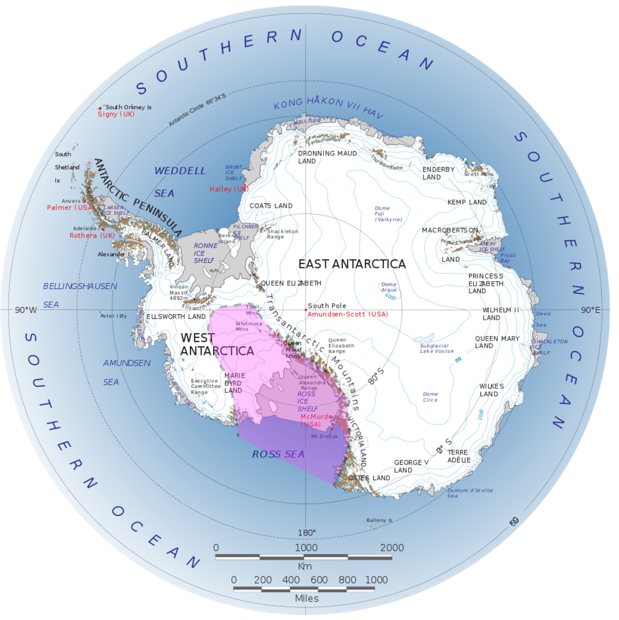
Map of Antarctica showing East Antarctica, the Transantarctic Mountains, the Antarctic Peninsula and the West Antarctic Rift System (shaded in rose). Outcropping rocks are shown in brown, ice sheets overlying water are gray, while white-colored land-grounded ice covers 98% of the continent’s surface.
Credit: BrucePL, CC BY-SA 4.0, via Wikimedia Commons - East and West Antarctica are very different from the standpoints of both their geology (old vs. young respectively) and their ice sheets (thicker vs. thinner respectively).
- The Greenwich (prime) meridian (0° longitude) is used to reference east and west for this southernmost of all continents.
- The Transantarctic Mountains are one of Earth’s longest mountain ranges at a length of more than 2000 mi (3500 km), effectively splitting the continent.
- Their highest summit is at 14,856 ft (4,528 m) at Mount Kirkpatrick in the Queen Alexandra Range along the rim of the Ross Ice Shelf.
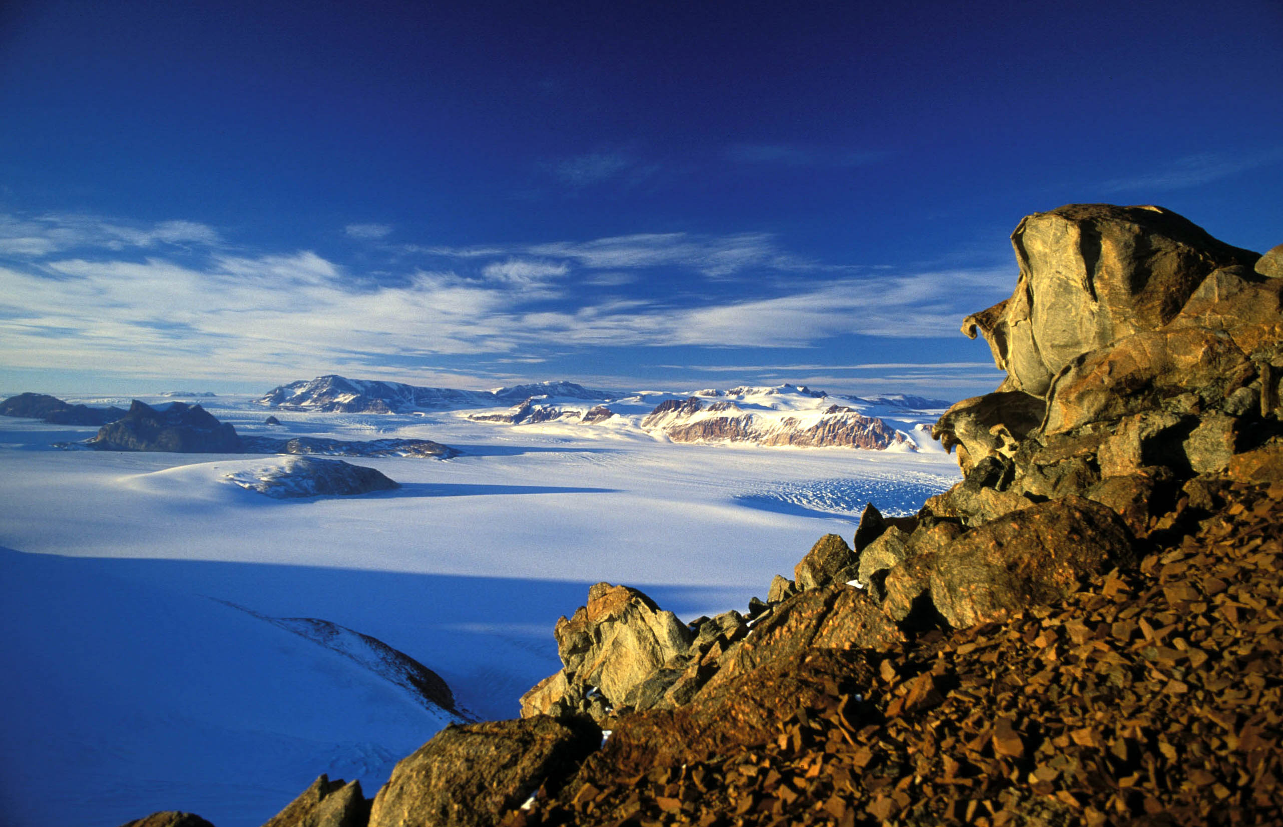
The Transantarctic Mountains cross Antarctica, separating the ancient cratonic core of East Antarctica from the younger tectonic systems of West Antarctica.
Credit: Hannes Grobe, Alfred Wegener Institute, CC BY-SA 2.5, via Wikimedia Commons - They began forming at the end of the Cretaceous Period as the West Antarctic Rift system developed during the breakup of Gondwana, exposing rocks of Precambrian, Paleozoic, Mesozoic, and Cenozoic ages.
- Their highest summit is at 14,856 ft (4,528 m) at Mount Kirkpatrick in the Queen Alexandra Range along the rim of the Ross Ice Shelf.
- East Antarctica hosts the previously mentioned fragments of ancient cratons in thick continental crust.
- Overlying these old cratonic rocks, the East Antarctic Ice Sheet is the larger, thicker and more dynamic part of the Antarctic Ice Sheet, that is more than 3 mi (5 km) thick in places. It flows north toward the Eastern Hemisphere (Africa, the Indian Ocean, and Australia).
- West Antarctica is home to the broad West Antarctic Rift System (about the size of America’s Basin and Range Province) that includes active volcanoes like Mount Erebus, as well as the continental margin magmatic arc that stretched along the Antarctic Peninsula toward Chile from 9-20 million years ago when Antarctica and South America separated to form the Southern Ocean.
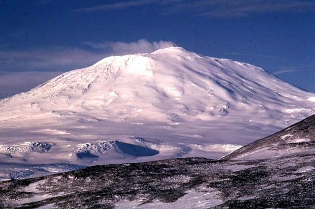
Mount Erebus is the highest active volcano in Antarctica and the southernmost active volcano on Earth. It is the second-most-prominent mountain in Antarctica, with a summit elevation of 12,448 feet (3,794 meters).
Credit: Richard Waitt, U.S. Geological Survey, public domain, via Wikimedia Commons- The West Antarctic Ice Sheet is a smaller and thinner section of the continuous Antarctic Ice Sheet that ranges up to 2 miles (3 km) thick. As it is less grounded on the land surface, it flows north toward the Western Hemisphere (South America and the Pacific) at faster rates compared to the East Antarctic Ice Sheet.
- Antarctica has a very long geological history, stretching back to the Archean Eon.
- The East Antarctic Shield hosts some of Earth’s oldest rocks with zircons dated at more than 3.8 billion years old in orthogneisses that are exposed in the Napier Mountains of Enderby Land (at about 2:00 on the Antarctic map).
- Along with the cratonic shield areas of other modern continents, these rocks participated in the assembly and breakup of the supercontinents of Nuna (2.5–1.5 Ga) and Rodinia (1.26–0.75 Ga).
- Then, Antarctica joined in the assembly of Gondwana, where it snuggled up against the ancient continental shields of Australia, India, Africa, and South America from about 570 to 160 million years ago.
- For about 150 million years, Gondwana merged with Laurasia to form the giant supercontinent of Pangea from the late Carboniferous to the Triassic.
- This long exposure resulted in extensive erosion of these old, thick continental cratons.
- Pangea began to break up in the Triassic Period, continuing through the Mesozoic. Today’s continents separated by the end of the Cretaceous.
- Starting during the Jurassic Period, a subduction zone extended along the Pangean coast that included West Antarctica, resulting in the amalgamation of smaller continental fragments and volcanic arc systems.
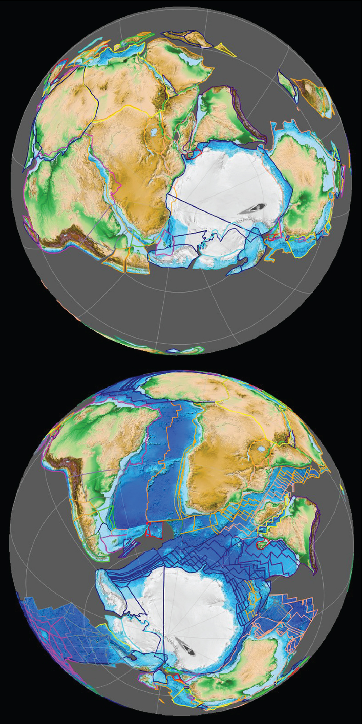
The assembled supercontinent of Gondwana 420 million years ago (top, late Silurian) and the Gondwana breakup in progress around 83 million years ago (bottom, Late Cretaceous). Portions of today’s Antarctic continent are outlined in navy blue in both views.
Credit: Fama Clamosa, CC BY-SA 4.0, via Wikimedia Commons - Western Antarctica’s Rift Zone and the Antarctic Peninsula that reaches toward Chile are still volcanically active today as vestiges of continental breakup and rotation, possibly reflecting a mantle plume.
- Antarctica iced up 34 million years ago when the climate cooled at the start of the Oligocene epoch.
- We know more about the geology of the moon and Mars than we do about the geology of ice-covered Antarctica. Scientific sleuths rely on geophysical remote sensing as well as clues from plate tectonics puzzle pieces to predict geological trends below the ice, which are key to understanding the formation and flow of Earth’s thickest ice.
- Plate tectonic reconstructions provide the identity and orientation of geological features of previously adjacent continents to help scientists better understand the possible configuration of rocks and geological structures below the Antarctic ice.
- In 2018 researchers produced a gravity derivative map from data collected during the European Space Agency’s Gravity Field and Steady-State Ocean Circulation Explorer (GOCE) mission which burned up in Earth’s atmosphere in 2013. The map shows thicker crustal domains in East Antarctica that are comparable to GOCE signatures from Australia’s Pilbara and South Africa’s Kaapvaal cratons. The gravity signature for West Antarctica suggests thinner crust as would be expected in an active rift system.
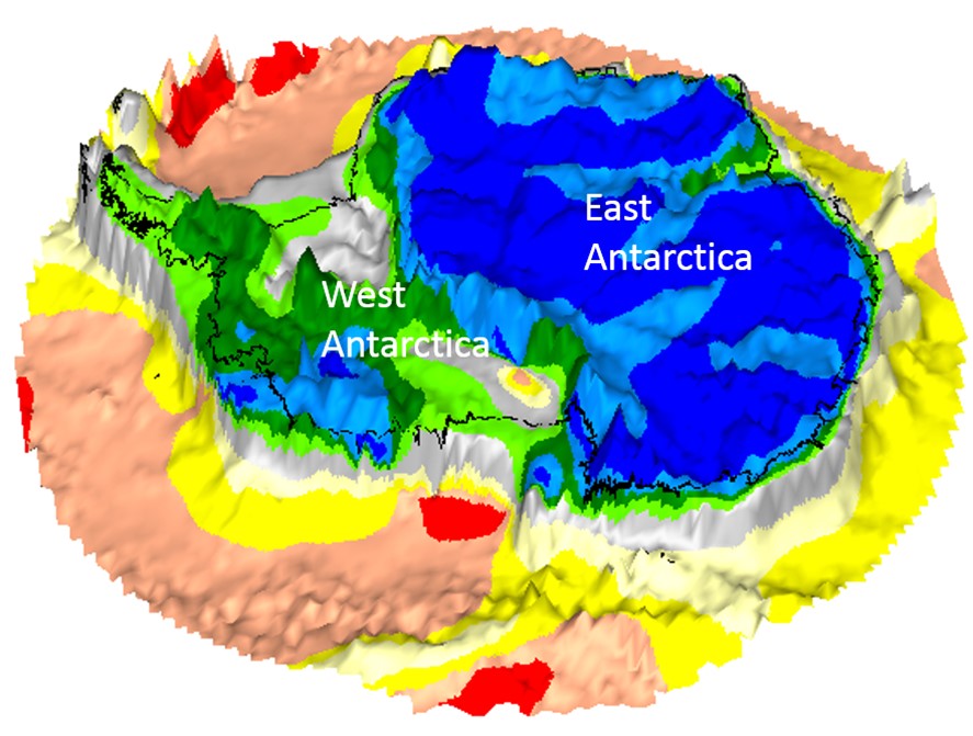
Gravity gradient shape index map of Antarctica draped on bedrock topography, derived from GOCE data.
Credit: European Space Agency - Also in 2018, geophysicists produced a 1.5 km (0.93 mi) grid of magnetic anomalies incorporating more than 2.2 million line mi (3.5 million line km) of both airborne and shipborne data. Magnetic anomalies can also be used to infer geological trends below the ice.
- Projects like NASA’s “Operation IceBridge” and the UK Polar Data Centre’s “Antarctic Bedmap” track ice surfaces over time and have produced topographic maps of the underlying land surface that indicate paleo drainage patterns along which glacial ice accumulated and still flows today.
- The detail of recent subglacial topographic surveys is truly amazing. In a recent aerial survey, detailed images of the surface of bedrock below a Maryland sized section of the East Antarctic Ice Sheet shows what appears to be the remnant topography of three large bluffs with intervening fjords (Highland A in Figure 1). While many subglacial landscapes have been bulldozed by moving ice, this area appears to have been frozen in time for 14 million years or more.

