Credit: Peter Hennings, Bureau of Economic Geology
Background
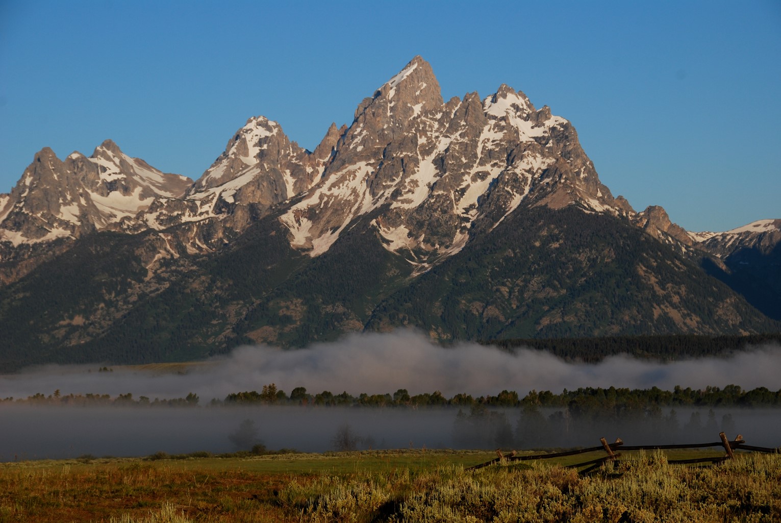
Synopsis: Grand Teton National Park contains North America’s youngest mountain range: the towering “Tetons.” While the range formed by extension along a tectonically simple “normal” fault, the Teton Fault is unique because it has moved nearly 33,000 ft (10 km) in just ten million years. Preserving astounding natural beauty and a human history stretching back at least 11,000 years, the national park was first established in 1929.
- Grand Teton National Park is located in northwestern Wyoming and includes the Teton Range and the adjacent valley of Jackson Hole.
- The Teton Range is a north-south oriented mountain front that is 40 mi (64 km) long in westernmost Wyoming. Grand Teton Peak rises more than 7000 ft (2133 m) above the surrounding valley floor to 13775 ft (4199 m) above sea level.
- Jackson Hole is the 55 mi (89 km) long valley to the East of the Tetons named by early fur trappers. The valley is 6-13 mi (10-21 km) wide with its lowest elevation of 6350 ft (1940 m) at the park’s southern boundary.
- The park includes around 485 square miles (310,000 acres, 1,250 square km) of mountains and valley floor.
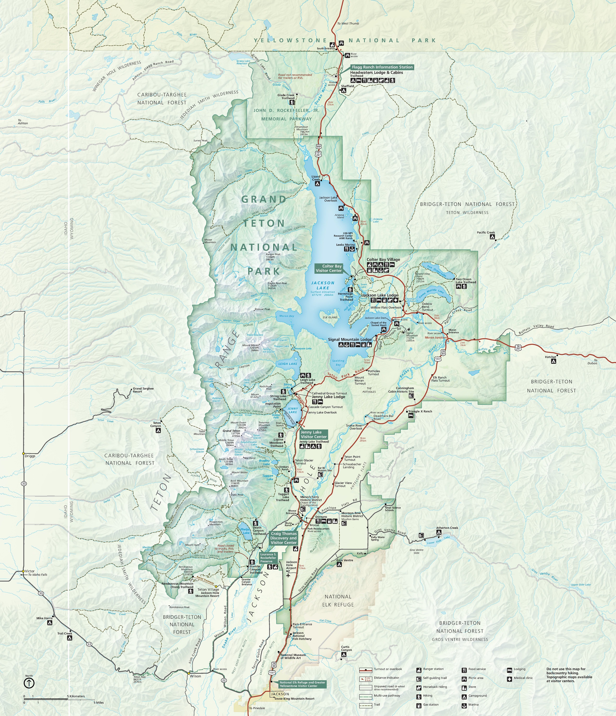
Map of Grand Teton National Park, Wyoming, USA. The vertical white line is the Idaho-Wyoming state border.
Credit: NPS - The park is home to a number of lakes including 15 mi (24 km) long Jackson Lake, as well as about a dozen small glaciers.
- The northern boundary of Grand Teton National Park is just 10 mi (16 km) south of Yellowstone Park. The two parks are connected by the John D. Rockefeller Jr. Memorial Parkway.
- More than three million global visitors enjoy the park each year, with more than 3.4 million in 2023.
- Teton Village has hosted the famous annual international Jackson Hole Economic Symposium since 1981.
- These breathtaking mountains, and the National Park that protects them, wouldn’t exist without the Teton Fault, a 44 mi (70 km) long normal fault that dips toward the east. The fault is located at the intersection of four provinces with long histories that have influenced the fault.
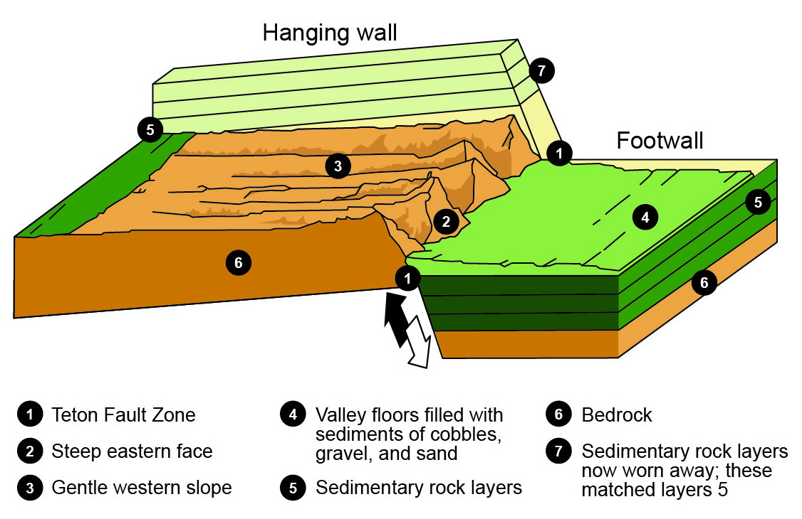
Schematic diagram of the Teton fault and the orogenesis of the Teton Range, Wyoming.
Credit: NPS, public domain, via Wikimedia Commons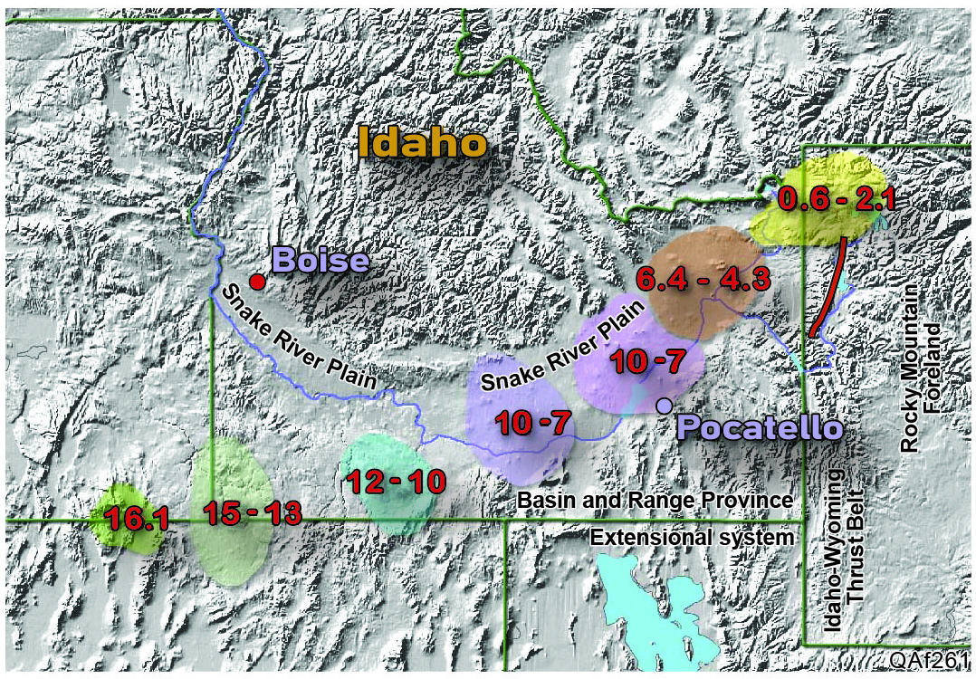
Location of the Yellowstone Hotspot. Numbers indicate the time of the eruption, in millions of years ago. The yellow area lies over today’s Yellowstone National Park. The Teton Fault is shown in red, with Lake Jackson to its east.
Credit: Kelvin Case at English Wikipedia, CC BY 3.0, via Wikimedia Commons- The Basin and Range province to its west is characterized by east-west crustal extension that began 17-20 million years ago, with dipping both east and west.
- To its east, the Rocky Mountain Foreland is a region of thicker, heavier continental crust that weighs down the hanging wall rocks to the east of the fault.
- To the South it is constrained by the deformed and thickened crust of the Idaho-Wyoming Thrust Belt.
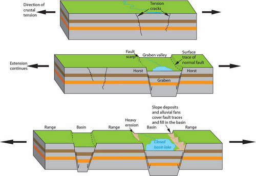
Unlike narrow rifts, the wide rift of the western U.S. is comprised of a series of horsts and grabens.
Credit: Trista L. Thornberry-Ehrlich/Colorado State University and the National Park Service , public domain, via OpenGeology.org - The Yellowstone Volcanic Plateau, at the northeastern end of the Snake River Plain, is a region of uplift and active tectonics underlain by the Yellowstone Hotspot north of the Tetons. As the young basalts of the Snake River Plain cooled, the crust subsides, tilting the footwall of the fault toward the west and lifting the Tetons upward.
- The Teton Fault strikes 10 degrees east of north (N10°E) with dips from horizontal ranging from 45°–75° degrees toward the east, with three segments that can move together or separately.
- It is a normal fault system, meaning much of its movement is vertical as the eastern hanging wall on the east slips down and slightly eastward along the fault. At the same time, the progressive tilt of the western footwall enhances the relative movement along the fault to produce its stunning relief.
- One of the fastest moving faults in the western United States, the Teton Fault has accumulated at least 20,000-33,000 ft (6-10 km) of movement with some estimates as high as 36,000 ft (11 km). A whopping 1 foot of episodic movement every 300 years!
- Scientists estimate that movement on the fault began about 10 million years ago, with most of its movement occurring in just the past 2 million years, making the Tetons the youngest mountain range in North America. Because they are so young they have not had time to erode allowing for the rugged relief observed today.
- At the end of the Pinedale glaciation from 14,000-16,000 years ago, fault movement increased dramatically along the Teton Fault as melting glaciers changed the distribution of stresses in the subsurface.

This near-vertical scarp along the Teton Fault is located on the lower face of Rockchuck Peak to the west of String Lake, Grand Teton National Park, Wyoming, USA. The scarp extends across the lower part of the image, marked by the horizontal band of trees on the mountainside.
Credit: Daniel Mayer, CC BY-SA 3.0, via Wikimedia Commons
- While most seismic activity in the area is associated with the Yellowstone Caldera, the Teton Fault has been characterized with the highest earthquake hazard ratings in the Rockies.
- Large earthquakes occurred along the fault around 4800 and 8000 years ago, and researchers have been able to show that earthquakes have occurred as frequently as every 1600-6000 years in the past.
- Using sedimentary records of deposits formed by past earthquakes in the valley, scientists estimate that the Teton Fault could produce future earthquakes with magnitudes as high as 7.5, that could offset the ground surface by as much as 10 ft (3 m). These could produce landslides that could change the course of the Snake River and destroy infrastructure in the valley of Jackson Hole.
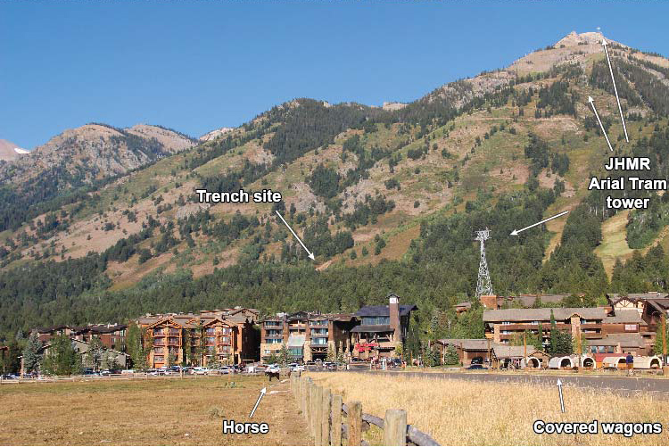
Jackson Hole Mountain Resort (JHMR) in Teton Village, Wyoming has been the location of the international Economic Symposium each August since 1981.
In 2017 the United States Geological Survey excavated a deep trench across the Teton Fault trace to study the fault plane as well as sediments that were deposited during and after several past earthquakes. The trench is labeled on this image, along with other features.
Credit: USGS
- The valley has been inhabited for more than 11,000 years when Paleo-Indian hunter-gatherers migrated into the valley seasonally to pursue prey.
- The eastern Shoshone occupied the region by the time the first European explorers entered the valley.
- From 1810-1840 fur trading for beaver pelts drew companies to the valley, while United States Government surveys took place in the mid-1800s, extending southward from Yellowstone.
- The first permanent settlement was established in Jackson in the 1880s.
- Soon afterward, efforts began to preserve the scenic area as a national park, and in 1929 Grand Teton National Park was established around the major peaks.
- In the 1930s, conservationists led by John D. Rockefeller Jr. began to purchase surrounding valley land to add to the park, setting aside this acreage as Jackson Hole National Monument in 1943. It was added to the National Park in 1950.
- Today the park affords visitors the opportunity to experience a nearly untouched wilderness with more than 1000 species of plants, 300 species of birds and dozens of species of mammals, reptiles, amphibians and fish.
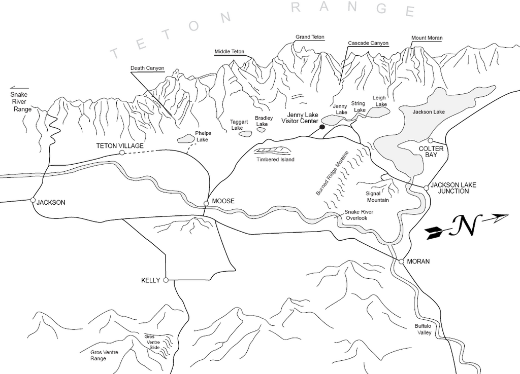
A perspective map of the Teton area
Credit: National Park Service, public domain, via Wikimedia Commons- It is popular for mountaineering, hiking, and boating, with visitor centers, motels, lodges, and marinas.
- It’s one of the few places in the world where fishermen can catch the Snake River fine-spotted cutthroat trout.
- More than 1000 drive-in campsites and more than 200 mi (320 km) of hiking trails are available in the park.
Episode Script
Grand Teton National Park got its name from its large, triangular mountains which looked, at least to one, early French explorer like, well, yes, large breasts.
The Tetons take their pyramidal shape because they’re the youngest mountains in the United States, not yet worn down by erosion, which rounds and flattens mountains over time.
Their steep sides are defined by an active fault, which has moved 5 miles vertically in the last 10 million years. That’s very speedy, for a fault. All that movement has produced several major earthquakes over the millennia.
Archaeological records show the first human visitors were nomadic Native American tribes, 11,000 years ago, who used the valley as hunting grounds.
In the 1800s, beaver pelts drew trappers who established the first permanent settlement in Jackson Hole. By the 1930s, led by John D. Rockefeller, conservationists preserved the area as a National Park.
Its unspoiled wilderness is home to a thousand types of plants, 300 kinds of birds, and hundreds of species of other animals. With 200 miles of hiking trails and a thousand campsites, if you haven’t visited, don’t wait!
You might not see the female forms that beckoned those lonely French trappers, and have amused Wyoming middle schoolers ever since.
But you will see some of the most spectacular mountain landscape this country has to offer.