
Credit: U.S. Army, public domain, via Wikimedia Commons
Have you ever seen those beautiful satellite images of Earth and wondered what camera could take them? The answer is no camera could.
They’re produced by a multispectral scanner developed in the 1950s at Hughes Aircraft by a team led by the young MIT scientist Virginia Norwood—known today as the “Mother of Landsat.”
Landsat, Earth-imaging satellites, were first launched in 1972 by NASA with the goal to survey the Earth’s surface in real time. The orbital path was set from pole to pole, and they could circle Earth several times a day, taking a full image of Earth every 18 days.
But how would they take that image? RCA developed a television-like system using camera lenses recording to early black and white video. But Norwood’s team had a different idea.
They captured light reflected from Earth, from within and outside of the visible spectrum, and separated it into multiple electromagnetic bands. They analyzed Earth’s surface using the different properties of each band. Finally, the bands were composited into an image.
Early satellites carried RCA’s and Norwood’s systems, but hers quickly won out and became the standard for satellite imaging, now covering Earth every eight days.
Norwood continued to advance the field for her entire career, until she retired in 1989—a pioneer whose work is used daily in agriculture, forestry, fisheries, geology, cartography, military applications and many other fields.
Background
Synopsis: For more than five decades, Landsat satellites have continuously monitored Earth’s surface using multispectral scanners that produce stunning digital images of our planet. Although they look like photos, these images are not produced by cameras, which are prone to distortion. These scanners were the first innovative step by scientists into the digital imaging that is the basis of modern remote sensing. The scanners were designed by physicist Virginia T. Norwood, who is now known as the “Mother of Landsat.”
- As the Space Race between the United States and the Soviet Union heated up in the late 1950s and early 1960s, astronauts and cosmonauts reported beautiful views of Earth from space.
- The Mercury and Gemini missions included cameras that recorded the first astonishing photographs of Earth from space.
- Weather satellites began monitoring Earth’s atmosphere in 1960, but the notion of observing Earth’s terrain from space didn’t gain traction until the mid-sixties.
- Given the utility of the Mercury and Gemini photographs, in 1965, the eighth director of the U.S. Geological Survey (USGS), William T. Pecora, proposed using remote sensing to assess Earth’s national resources.

William T. Pecora, a geologist, served as director of the U.S. Geological Survey from 1965 to 1971 and as undersecretary of the Department of the Interior from 1971 until his death in 1972. Pecora advocated for the potential of remote sensing for Earth observation. He died just four days before the July 23, 1972, launch of the Landsat 1 satellite, which began the fulfillment of his vision and a 50-year-plus legacy. He has been called the “Father of Landsat.”
Credit: USGS - This was first accomplished using cameras mounted on high-altitude aircraft, but in 1966, the Department of the Interior announced it would build its own satellite for the purpose of observing Earth.
- There were geopolitical concerns about photographing secret military operations and foreign countries, but by 1970, NASA began construction of an Earth-observing satellite, the Earth Resources Technology Satellite (ERTS), that would be renamed Landsat 1 in 1975. Landsat is managed by the USGS and NASA.
- Experts disagreed about how best to collect usable data, so ERTS (Landsat 1) carried two experimental technologies. The larger, less controversial system was RCA’s Return-Beam Vidicon (RBV), a television-like camera with conventional lenses that returned full scenes of black and white, visible–near-infrared photographic images of Earth in three wavelength bands.
- The RBV produces photometric images that characterize light’s interaction with the human eye, known as luminous flux, which is measured in lumens.
- In 1964, the NASA space probe Ranger 7 carried six RCA television vidicon cameras as it hurtled toward the lunar surface, successfully transmitting more than 4,300 photographs before crashing into Mare Cognitum, so scientists expected the similar technology of the RBV to succeed.
- The smaller system carried by Landsat 1 was a completely new technology designed and produced in just nine months at the Hughes Aircraft Company Santa Barbara Research Center. This multispectral scanner (MSS) prototype collected the intensity of reflected light filtered into four wavelength bands. The basic design remains in use today.
- Optical radiometric techniques, used by the MSS, characterize the power of electromagnetic radiation in space, known as radiant flux, which is measured in watts.
- Because the size of the RBV vidicon system expanded as launch time approached, the 100 lb (45 kg) MSS had to fit into an even smaller space than its original design, so the plan to include six wavelength band sensors was reduced to just four sensors (additional sensors have been added in newer satellites).
- The concept of gathering digital reflection strength data by wavelength band in rectangular pixels registered to latitude and longitude using a pivoting mirror system was so innovative that many scientists didn’t understand it, expressing skepticism that it would work.
- Multispectral scanners passively record reflected electromagnetic energy in multiple wavelength bands, building up an image line by line as the satellite moves forward.
- The sensors for the MSS are line-scanning devices that collect data perpendicular (cross-track) to the orbital path of the satellite. An oscillating mirror simultaneously scans six lines in each of four spectral bands. The forward motion of the satellite provides north–south (along-track) progression for data collection.
- Energy from photons striking the detectors is sent to a multiplexer that translates measurements into digital data that is combined, streamed to the ground and unscrambled.
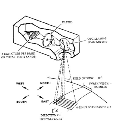
Diagram of the function of the first Multispectral Scanner (MSS), designed by Virginia T. Norwood, on the Earth Resources Technology Satellite (ERTS) that launched on July 23, 1972. The satellite was renamed Landsat 1 in 1975.
Credit: NASA Landsat Science - For each MSS wavelength band over an area, a digital map can be created pixel by pixel from the intensity of light reflected from that pixel in that wavelength band. When multiple bands are colorized and stacked, they create “composite MSS false-color” images that can look a lot like photographs, depending on the bands and colors combined.
- This groundbreaking technology was engineered and prototyped by Virginia T. Norwood, a brilliant young MIT mathematical physicist whose colleagues thought of her as someone who could solve just about any problem.
- Norwood graduated in 1947 and found a position at the U.S. Army Signal Corps in New Jersey working on weather radar. She invented a radar reflector for weather balloons.
- After five years, she and her husband moved to Sylvania Electronic Defense Labs in Mountain View, California, setting up Sylvania’s first antenna lab.
- A year later, she was hired by Hughes Aircraft Company to work on antenna design, microwave systems, communication links, optics and the Landsat multispectral scanners.
- She worked on the Surveyor transmission systems that beamed back the first photos of the Moon in 1966.
- Along with several talented specialists at Hughes, she designed the multispectral scanner prototype for Landsat 1, testing it out at Half Dome in Yosemite National Park before launch.
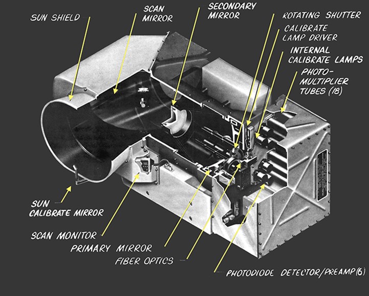
Diagram of the four-band MSS. The photomultiplier tubes and silicon photodiodes are tucked in the rear of the sensor.
Credit: Hughes/NASA
- On July 23, 1972, Landsat 1 launched from Vandenberg Air Force Base, California.
- Landsat 1 orbited 570 mi (970 km) above Earth 14 times a day, circling once every 103 minutes.
- Its orbit was Sun-synchronous—it always stayed in the Sun because it needed to collect reflected sunlight. Its orbit was near-polar, running from north to south.
- It repeated the same path every 18 days, demonstrating changes to Earth’s surface.
- About two weeks into the mission, the RBV was found to be producing an electrical transient that interfered with altitude control, so it had to be shut down to maintain operation of the satellite. That experiment was over for Landsat 1.
- Scientists weren’t sure what to expect from the MSS experiment. At first, when raw data started coming in, technicians couldn’t figure out why it looked so curvy, but then they realized it was correctly imaging the wavy shapes of Arkansas’s folded Ouachita mountains.
- On July 25, 1972, the first false-color image successfully composited from Landsat 1 data showed the Dallas–Fort Worth region of Texas.
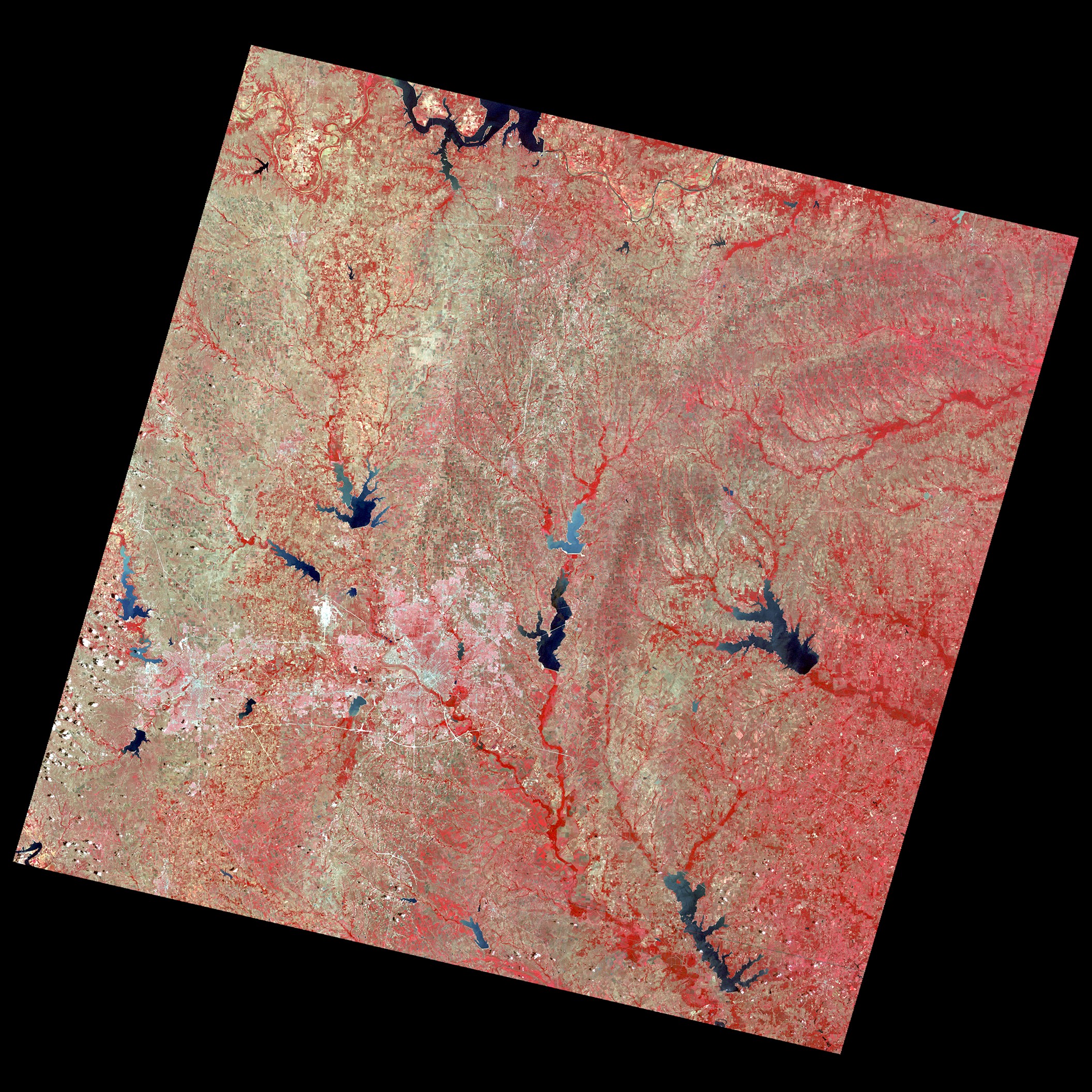
The very first false-color image produced from Landsat 1 MSS data was of Dallas–Fort Worth, Texas on July 25, 1972. In this image, shades of red indicate vegetated land and grays and whites are urban or rocky surfaces. The composite image is shown using the near-infrared, red and green bands and each pixel is 197 ft (60 m) square.
Credit: USGS
- The most recent Landsat satellite, Landsat 9, launched on September 27, 2021.
- Over the past five decades, multispectral scanners and other instruments on Landsat orbiters have collected millions of images that can be accessed at the USGS EarthExplorer website.
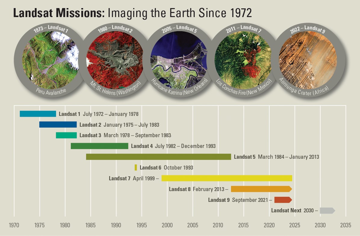
This Landsat Missions Timeline shows continuous Landsat program operation since 1972, providing more than 50 years of imaging of Earth’s surface.
Credit: USGS - Today, Landsat data is used in many different fields, including agriculture, forestry, fisheries, hydrology, geology, cartography, military applications and hazard surveillance and assessment.
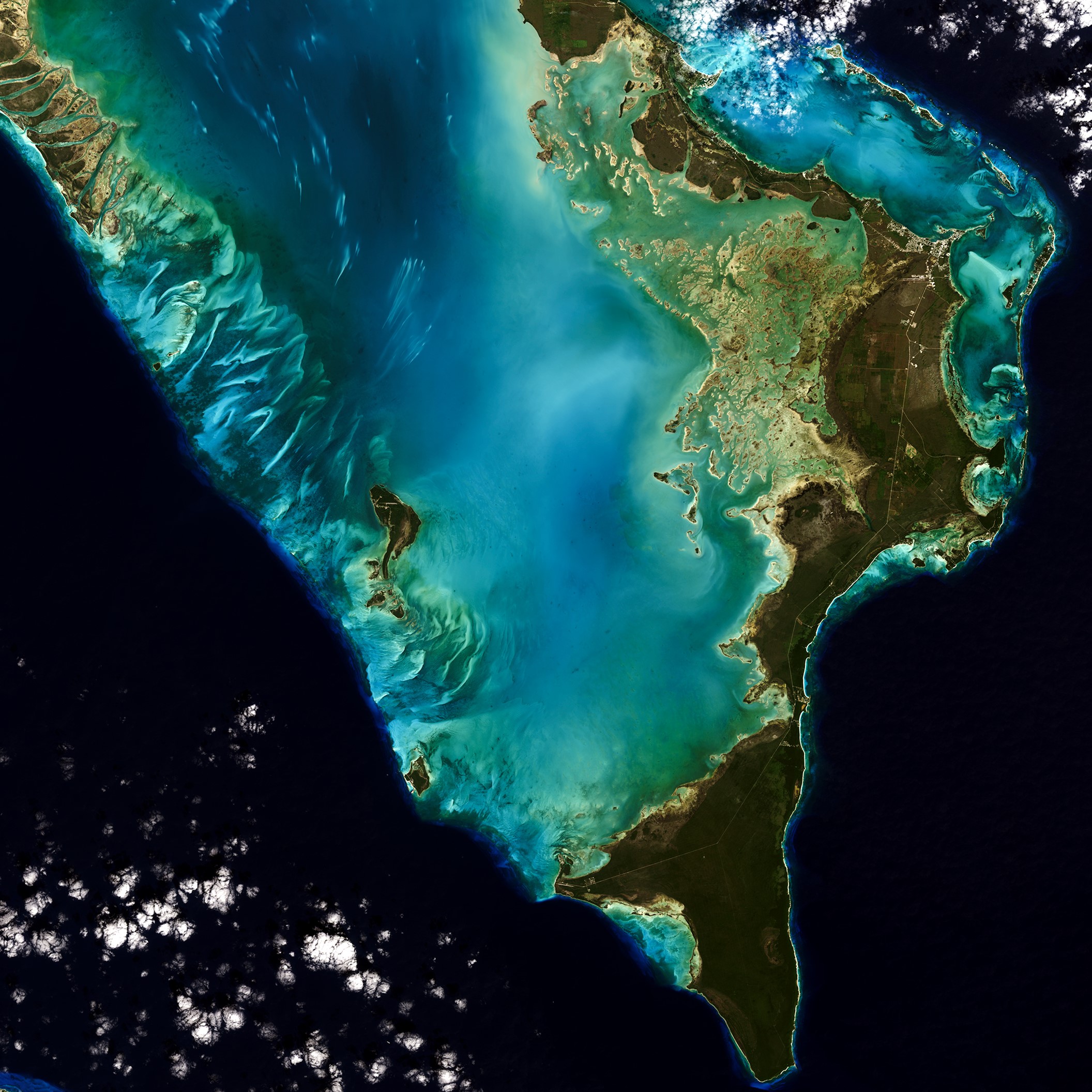
Not a photograph, this natural-color digital image of Abaco Islands, the Bahamas, as seen by Landsat 9 on January 18, 2022. Today, the Landsat program delivers complete coverage of Earth’s surface every eight days from both Landsat 8 and Landsat 9.
Credit: USGS
- Over the past five decades, multispectral scanners and other instruments on Landsat orbiters have collected millions of images that can be accessed at the USGS EarthExplorer website.
- As Landsat systems evolved, the number of bands expanded, providing more specific wavelength information, and the precision of the measurements improved, increasing horizontal resolution so smaller items could be imaged.
- Landsat 1, 2 and 3 each carried a payload consisting of an RBV as well as a four-band MSS. Resolution was about 197 ft (60 m), and passes repeated every 18 days.
- Landsat 4 and 5 carried an MSS and thematic mapper for seven bands, more like Virginia Norwood’s original design.
- Landsat 6 failed to reach orbit, but its twin, Landsat 7, included the Enhanced Thematic Mapper Plus, with eight bands.
- Landsat 8 and 9 have two devices, the Operational Land Imager (OLI) and the Thermal Infrared Sensor (TIRS) for 11 bands. Resolution for the panchromatic band is just 49 ft (15 m). These two satellites provide repeat passes every 8 days.
- The future of Landsat is bright, including collaboration with the European Space Agency’s Sentinel-2 constellation and even more bands for discrimination of various Earth environments.
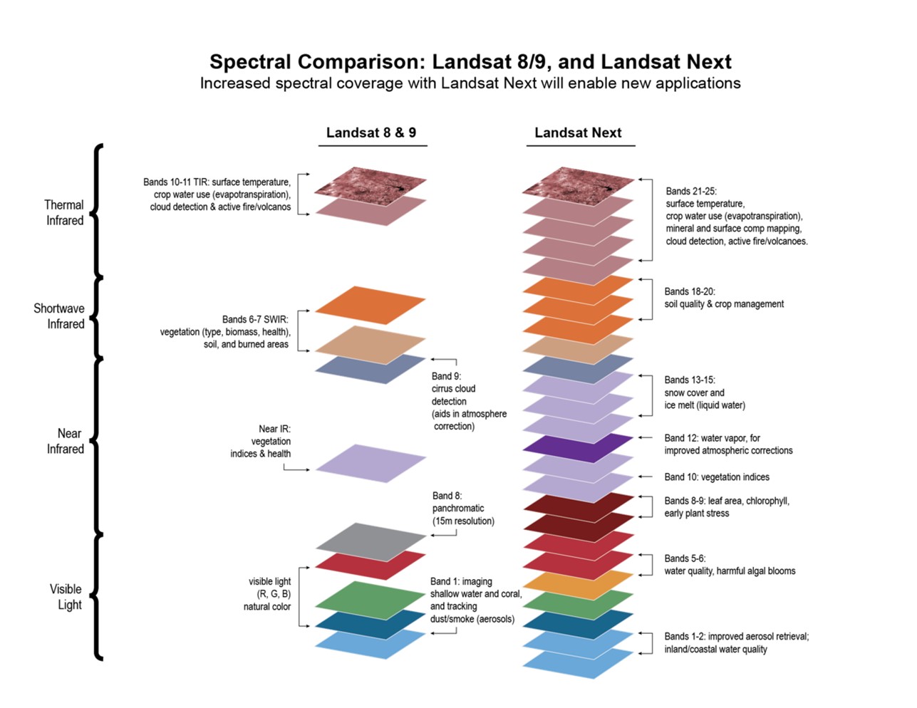
Comparing wavelength bands from Landsat 8 and 9 to the next-generation Landsat NEXT mission, planned to launch in the 2030s.
Credit: NASA, public domain, via Wikimedia Commons