
Credit: Albert Bierstadt, public domain, via Wikimedia Commons
Background
Synopsis: Forty-five years ago, North America witnessed its largest volcanic eruption in recent history when Mount St. Helens in Washington state erupted. While the lives lost in this tragic event will always be remembered, the devastated region has shown remarkable ecological recovery. In the years since, extensive studies have unraveled the mystery of how this volcanic mountain formed in such an unexpected location.
Credit: Lyn Topinka, public domain, via Wikimedia Commons
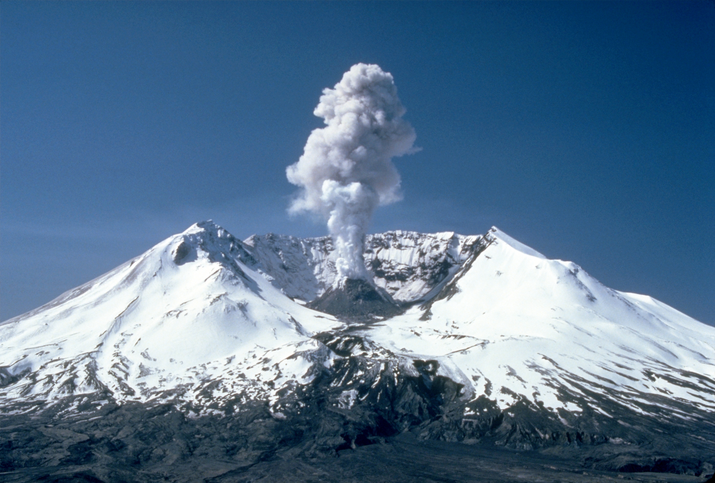
- Mount St. Helens, one of 20 volcanic peaks in the Cascade Range, is known for its dramatic eruption in 1980 that reshaped both its structure and the surrounding environment. The indigenous Cowlitz people named it 'Lawetlat’la,' meaning 'the smoker,' reflecting its volcanic nature. The 18th century English navigator George Vancouver renamed the mountain in honor of a British diplomat. The enormous mountain located 52 miles (83 km) northeast of Portland, Oregon, had been dormant since 1857. That changed in 1980.
- Early in 1980, as tremors and earthquakes began in the region and geologists began to flock to the mountain. By March 1980, a growing bulge on the northern side of the mountain expanded at a startling rate of 6.5 feet (2 meters) per day, alarming geologists and onlookers alike.
- The pristine snow and glaciers at the top of the mountain turned gray from the variable plumes of ash that spewed from the rumbling peak.
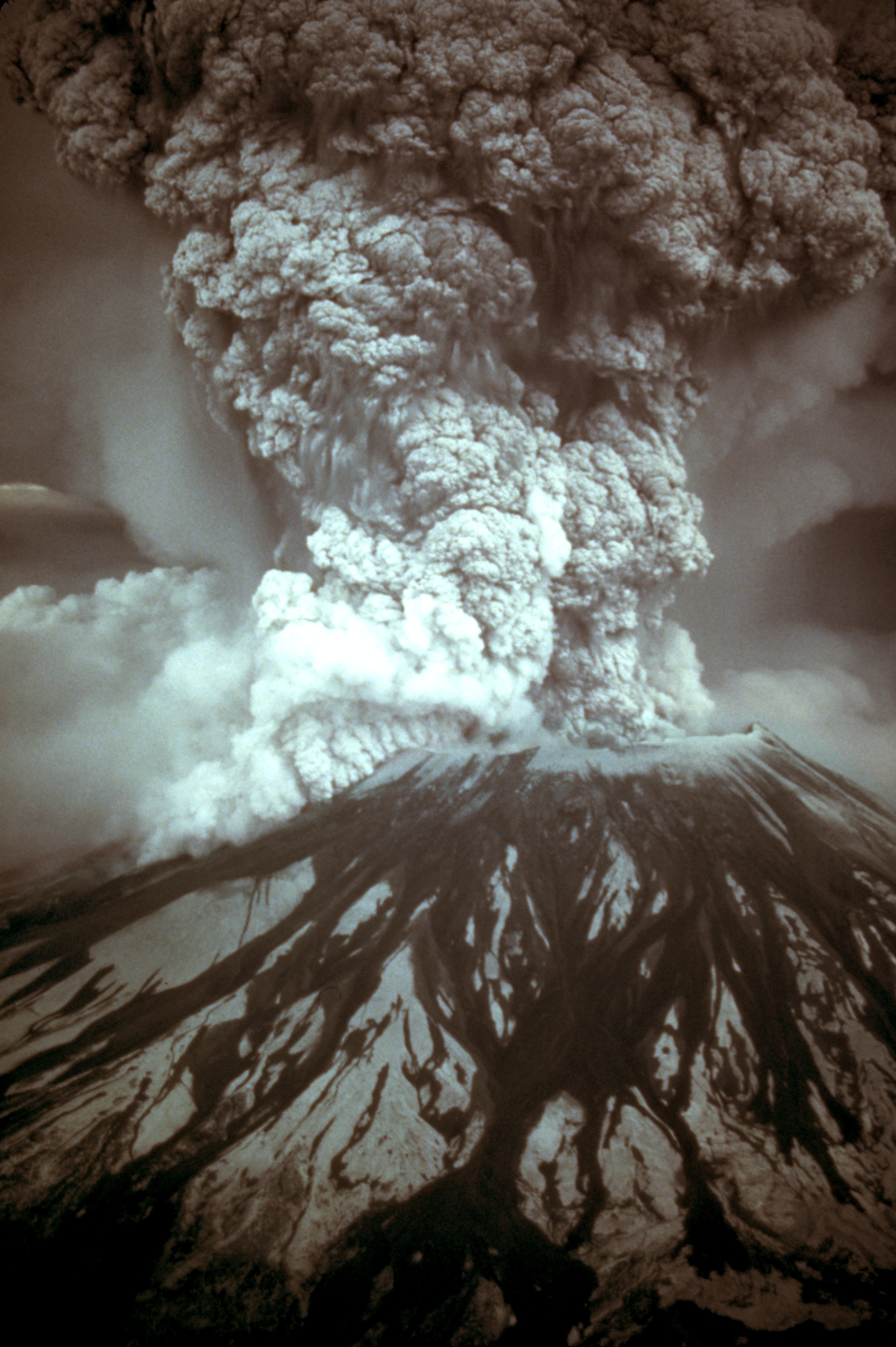
- On May 18, 1980, the mountain erupted violently. Pressure from the magma below caused a mile-long crack to open on its northern face, triggering the largest modern landslide above water ever recorded. The explosion sent a lateral blast of hot rock and gas through the forest, shearing the mountain’s peak and creating a massive crater.
- As ash and gas surged skyward, volcanic lightning illuminated the ash plume, created by static electricity from the ash particles.
- The lateral blast devastated 230 square miles (596 square kilometers) of recreation, timber, and private land, burying 14 miles of the North Fork Toutle River and destroying 185 miles (298 km) of highways, 47 bridges, and 200 homes. The eruption claimed 57 lives, mostly due to ash inhalation.
- After the eruption, the mountain height was decreased from 9677 feet (2950 meters) to 8363 feet (2549 meters) and created a 1-mile (1.6 km) horseshoe-shaped crater. Twenty-four square miles (62 km2) of valley was filled by a debris avalanche.
- The volcano has become active multiple times since the 1980 explosion and is under constant monitoring by the US Geological Services. Scientists are still uncovering mysteries of Mount St. Helens.

On May 18, 1980, at 8:32 a.m. Pacific Daylight Time, a magnitude 5.1 earthquake shook Mount St. Helens. The bulge and surrounding area slid away in a gigantic rockslide and debris avalanche, releasing pressure, and triggering a major pumice and ash eruption of the volcano.
Credit: Austin Post, public domain, via Wikimedia Commons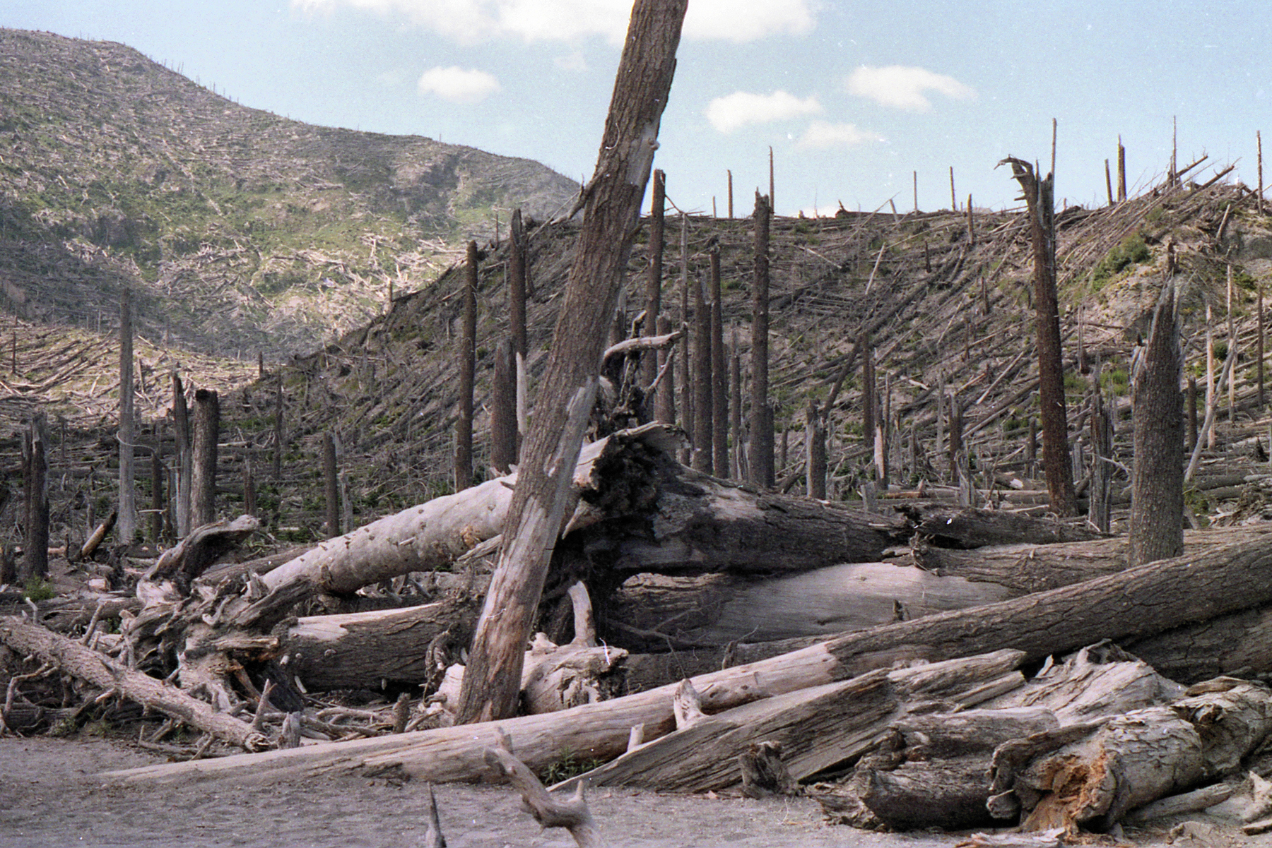
The blast toppled trees like they were toothpicks. The U.S. Forest Service later did some salvaged logging in the area.
Credit: Larry D. Moore, CC BY 4.0, via Wikimedia Commons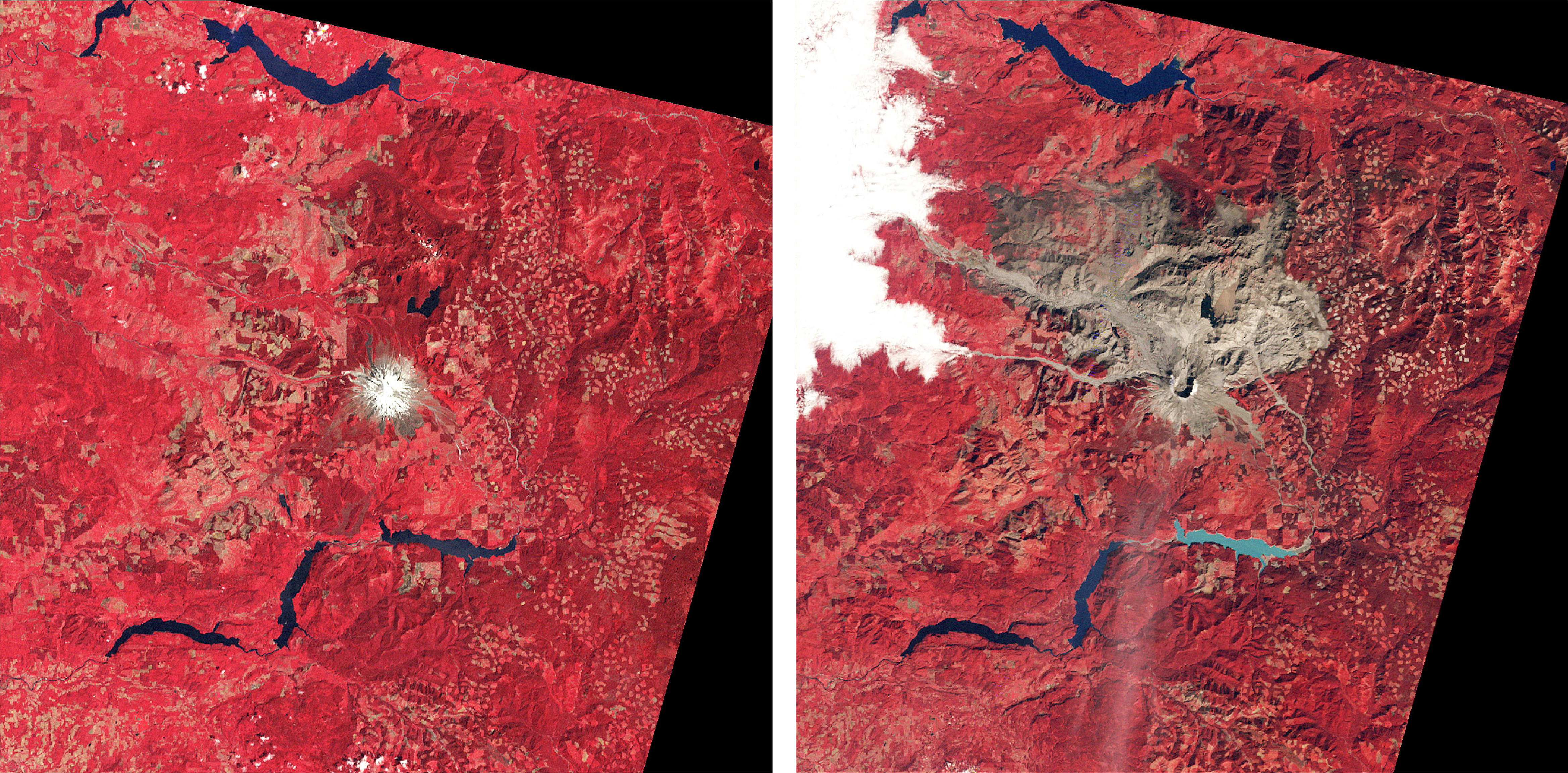
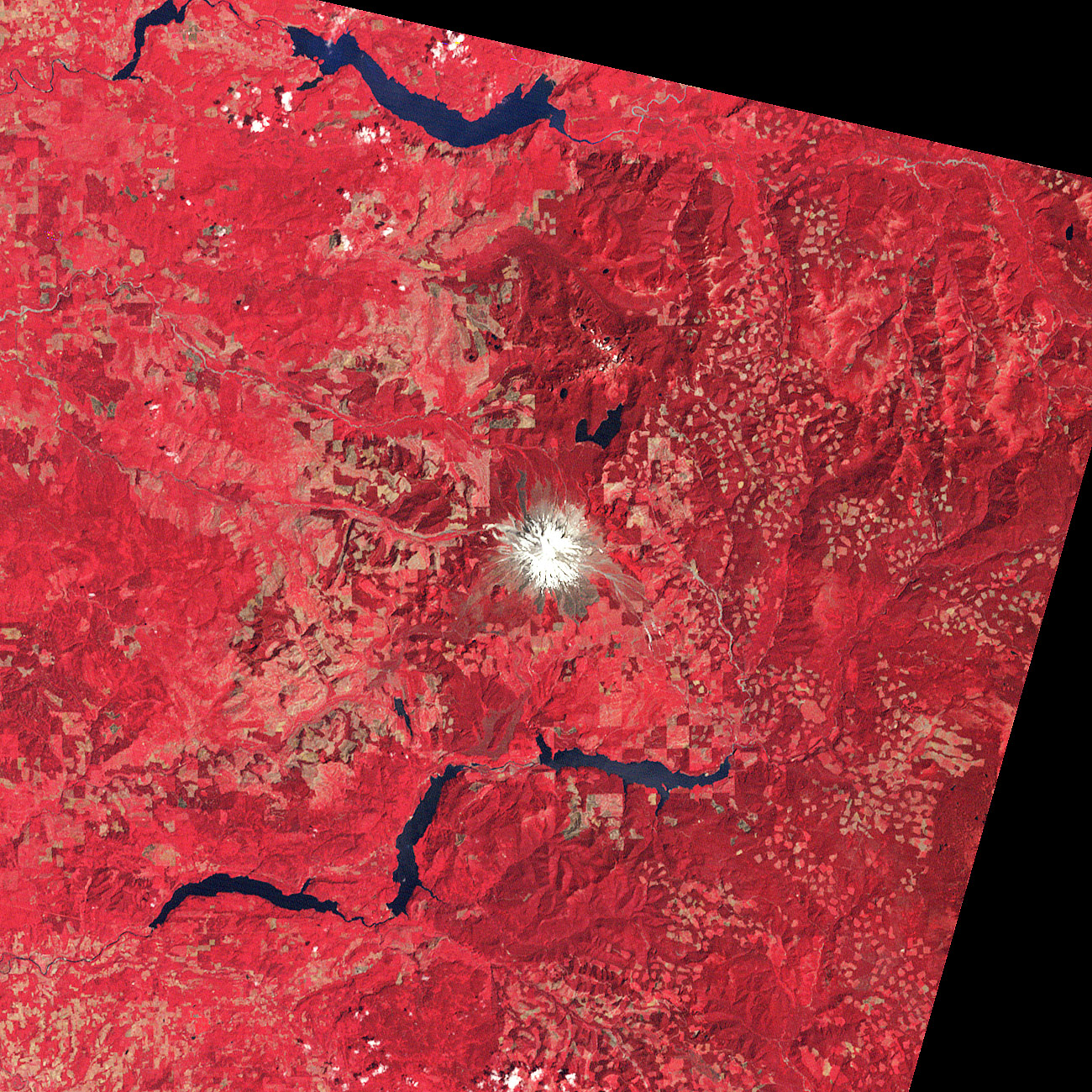
The astounding devastation of the eruption is shown by comparing Landsat images of Mt St Helens on August 29, 1979 and on September 24, 1980. In the right image, light blue Swift Reservoir is about 9 mi (14.5 km) long.
Left Credit: NASA Right Credit: NASA
- When you examine a map of the volcanic mountains in the Cascade chain, Mount St. Helen’s stands out from the rest sitting roughly 25 miles (40 km) to the west of the others in the range. Most mountains in subduction zones form directly above where the oceanic slab descends, which is 62 miles (100 km) beneath the surface for the other volcanoes in the Cascade Range. But since Mount St. Helens lies to the west, it is just 42 miles (68 km) above the subducting plate.
- Geologists believed they had a clear understanding of how the Cascade Range was formed. Just offshore of the Pacific coastline, the dense, oceanic Juan de Fuca plate plunges beneath the less dense, continental North American Plate. But this didn’t explain the unique position of Mount St. Helens and explain why it might be more active than other volcanoes in the Cascade Range.
- Using nearly every geological analysis tool available, the Imaging Magma Under St. Helens project, or iMUSH, set out to understand why this mountain is unique in the Cascade Range.
- One group drilled boreholes and set off blasts around the mountain, analyzing the movement of the seismic waves. They also studied how tremors from global earthquakes and large ocean waves traveled through the region.
- Teams also explored the types of rocks on the mountain including the specific chemistry of the rock samples.
- Another team explored the conductivity found below the surface, taking measurements of both magnetic and electric fields.
- Through this massive multi-disciplinary approach, they were able to uncover a deeper understanding of the geological history of Mount St. Helens.

Plate tectonics of the Cascade Range. The Cascade Range forms a line roughly parallel to the Pacific coastline, especially in Washington State and Northern Oregon. Researchers recently determined that the large, buried Spirit Batholith that occurs along the line appears to deflect lava westward toward Mt St Helens (note that Mt St Helens and Mt Adams are offset on either side of the line).
Credit: Surachit, CC BY 3.0, via Wikimedia Commons
- Millions of years ago, there was a volcanic region called Siletzia located off the west coast of North America. About 50 million years ago, tectonic forces pushed Siletzia into North America, merging the two regions.
- During this collision, ocean sediments were compressed and buried under the surface, eventually transforming into a type of rock called metasedimentary rock.
- As part of the iMUSH research, scientists used a technique called magnetotellurics to identify different types of rocks below Mount St. Helens. This method tracks how well rocks conduct electricity.
- They found that metasedimentary rocks, formed from ancient ocean sediments, exist beneath Mount St. Helens. These rocks are very conductive due to their carbon and sulfur content, making them stand out in scans.
- East of the Mount St. Helens, there is a large body of cooled, hardened magma (called a batholith) from ancient volcanic activity.
- The batholith and metasedimentary rocks affect how magma moves underground:
- The batholith acts as a barrier, preventing magma from rising to the east.
- The metasedimentary rocks might help guide magma upward, leading to volcanic eruptions.
- A dense layer of rock, likely part of Siletzia, blocks magma from flowing westward. This creates a unique zone where Mount St. Helens forms.
- Scientists don’t yet have a complete understanding of the deep structures beneath Mount St. Helens. While they have mapped some features, deeper layers remain unclear.
- Parts of Siletzia are visible above ground west of Mount St. Helens, but to study its exact role in magma movement, researchers must rely on data and imaging methods.
- This unique combination of ancient tectonic collisions, different rock types, and barriers beneath the surface helps explain why Mount St. Helens is located where it is and how it behaves.
- Despite the devastation in 1980, the Mount St. Helens’ ecosystem began recovering almost immediately, showcasing nature’s resilience.
- Just weeks after the eruption, ecologists spotted green shoots of fireweed (Chamaenerion angustifolium) growing from surviving roots. Evidence of beetles, burrowing animals, and elk tracks soon followed, signaling the first steps toward recovery. They were shocked to find any life in the barren landscape.
- Even more shocking, streams in the area were clear. The ash had settled, and the water was flowing.
- Lupines, critical for nitrogen fixation, spread across the landscape, joined by trillium and huckleberry. Lakes and waterways that were partially frozen during the blast provided refuge for fish and amphibians, aiding aquatic ecosystem recovery.
- Lakes and waterways that had some snow and ice present when the blast occurred provided a safe refuge for fish, salamanders and macroinvertebrates.
- The U.S. Forest Service salvaged logs from mudflows and replanted thousands of acres with fir and other species to prevent erosion, creating habitat for returning wildlife.
- Today, the Gifford Pinchot National Forest and Mount St. Helens Institute offer visitors a chance to explore this dynamic region and witness its remarkable recovery firsthand.
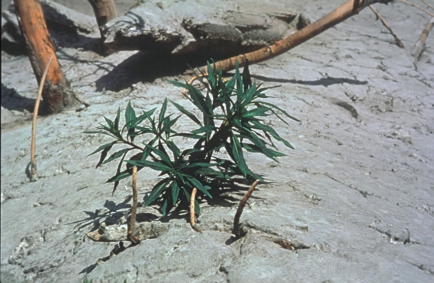
Observed just weeks after the eruption, fireweed (Epilobium angustifolium) sapling breaking through ash layers.
Credit: Jerry Franklin/USFS, public domain, via Wikimedia Commons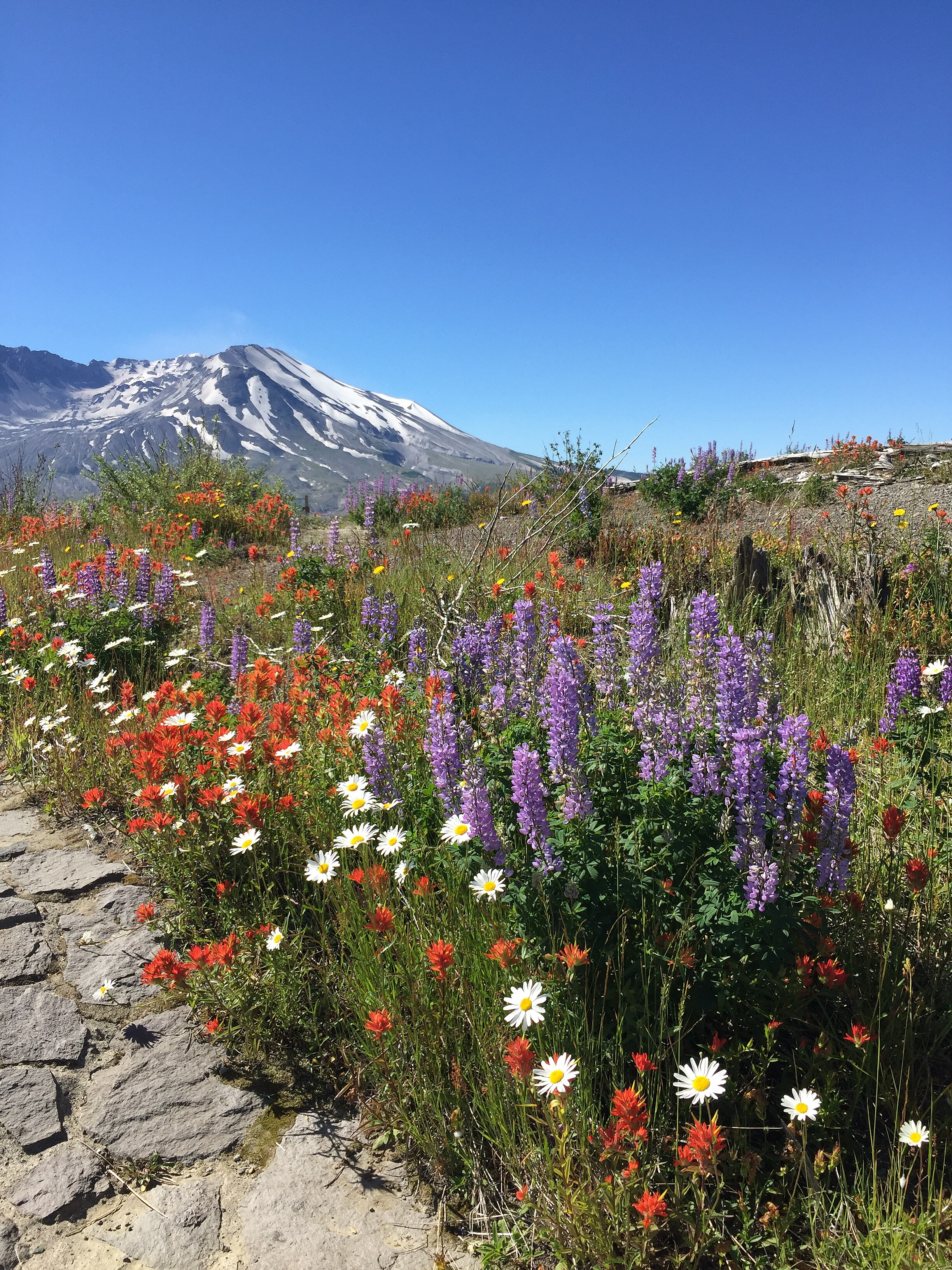
Although very much altered, Mount St. Helens is still a dominant presence in the Cascade Range.
Credit: LilaMusso, CC BY-SA 4.0, via Wikimedia Commons
Episode Script
The blast was over a thousand times stronger than Hiroshima, heard 700 miles away. It killed 57 people and countless animals.
This was the eruption of Mount St. Helens 45 years ago in Washington, the deadliest, most damaging volcanic event in modern US history.
Surprisingly, in America today there are 169 active volcanoes. Most are in Alaska. A few in Hawaii have small eruptions regularly.
There are 20 volcanoes in Washington and Oregon, where the Juan de Fuca tectonic plate subducts under North America, melting as it’s pushed down into Earth’s mantle, and rising to produce volcanoes at the surface.
A few are active, but St. Helen’s is different. It’s 25 miles west of the others, where the tectonic subduction zone is 20 miles nearer the surface.
In 1980, magma blasted sideways through a mile long gash on the side of the mountain. on the side of the mountain, flattening trees in an 8-mile radius. Pyroclastic flows set forest fires. Mudslides filled lakes and diverted rivers, causing massive floods.
But within weeks, fireweed sprouted from roots. Lupine and huckleberry crept across the landscape. Insects, burrowing animals and elk soon returned. Aquatic ecosystems rebounded.
Today, the top of the peak is gone, replaced by a huge caldera. But new trees have grown tall and the forest has returned.
An amazing testament to the resilience of nature. I’m Scott Tinker.