Credit: USGS
At the bottom of the ocean lies a treasure. But recovering it could be technically difficult, geopolitically challenging, and environmentally damaging.
Eighty three percent of the ocean is a mile deep, or much more, making the deep ocean the largest environment on Earth, covering 115 million square miles.
Down there, like in the Amazon, species diversity is high. There may be thousands of species we have not yet identified.
Down there, also, are polymetallic nodules and crusts, formed of iron and manganese, and in smaller amounts, cobalt, lithium, molybdenum, rare earth elements and other valuable metals that precipitate out of seawater, very slowly, over millions of years.
Many of these metals are used in new energy technologies, like batteries, so companies and countries are considering recovering them. But it’s complicated.
Most of the deep ocean is in international waters. No one’s quite sure how to regulate or share revenue from mining there.
And the deep ocean is a poorly understood environment. Mining could kill many creatures and damage seafloor ecosystems.
So far, no permits have been issued. But there is pressure on international authorities to do so, as today’s supplies of many of these materials are limited.
Efforts to mine the deep ocean, responsibly and sustainably, may be an area of dispute—and opportunity—in the future.
Background
Synopsis: As nations of the world look at future energy options, the need for certain raw materials is increasing, straining known available land-based resources. Miles below the ocean surface marine mineral deposits called polymetallic nodules and crusts concentrate key metals by adsorption onto their porous surfaces over millions of years. But the fragile seamount and abyssal plain biodiversity that lives among the mineral deposits is not fully understood. Exploitation of resources in this undersea wilderness is, and will likely remain, controversial.
- Earth’s abyssal zone covers about 60% of Earth’s surface, making it Earth’s largest environmental realm.
- It encompasses 83% of ocean basin floors, an area of 115 million square miles (300 million square km). The surface of the oceans covers 71% of Earth’s surface.
- The abyssal plain begins where seawater temperature drops to 39°F (4°C) at depths ranging from 1.25 to 2.5 mi (2,000–6,000 m) and extends to 3.75 mi below sea level (6,000 m) where the hadal zone begins. Seamounts jut out from abyssal plains due to volcanic activity. Not all oceans are deep enough to have a hadal zone.
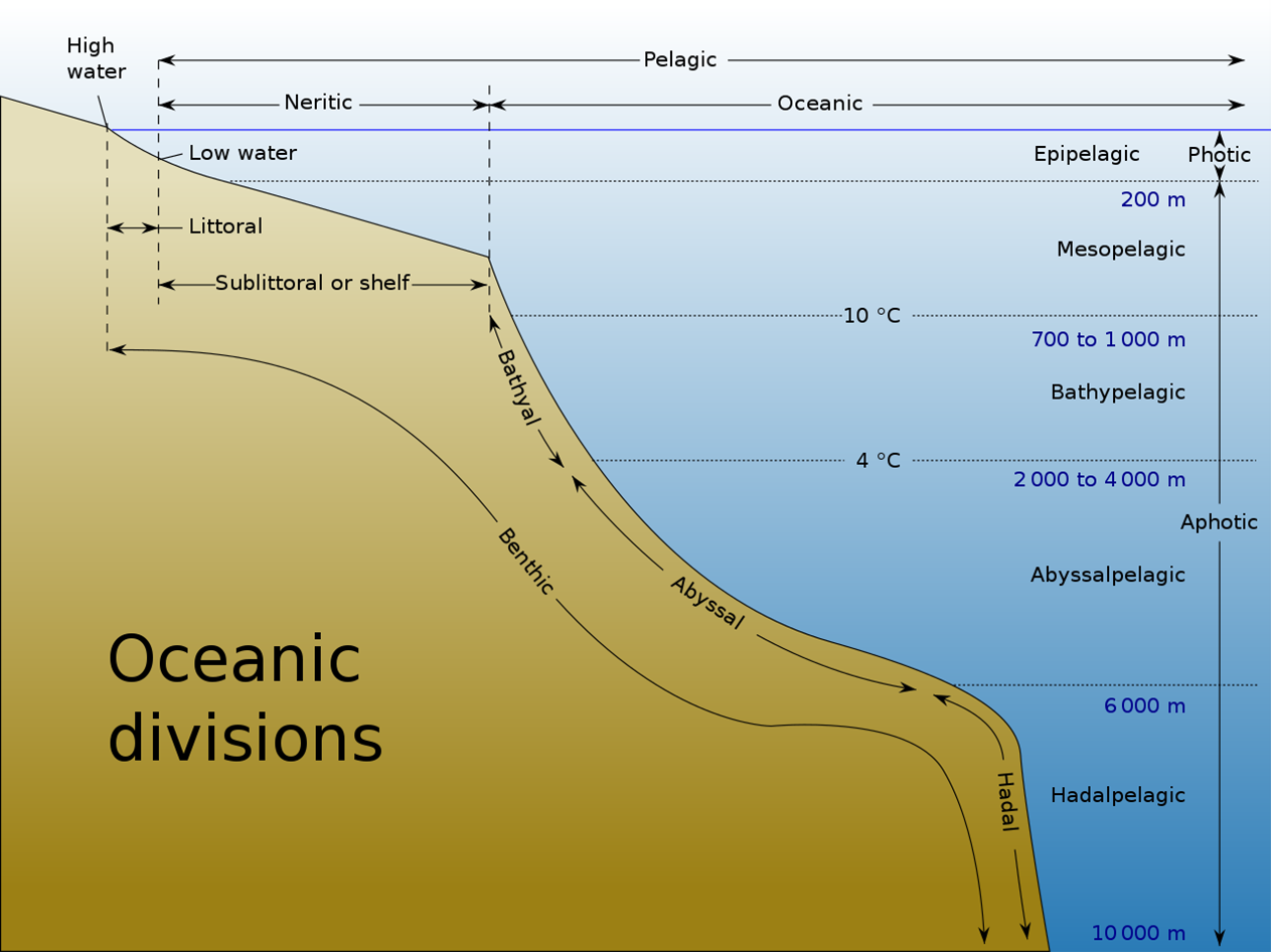
Depiction of the abyssal plain in relation to other major oceanic zones. The bathyal zone includes the continental slope and continental rise.
Credit: K.Aainsgatsi at en.wikipedia, public domian, via Wikimedia Commons - Scientists have already sampled a large diversity of alien-looking creatures that inhabit the plains and seamounts of the abyssal zone, while its low accessibility means we are still discovering remarkable species and habitats.
- Like the Amazon rainforest, species diversity is high, and some of these creatures may hold undiscovered medical and evolutionary secrets. We don’t yet understand the potential value of these ecosystems.
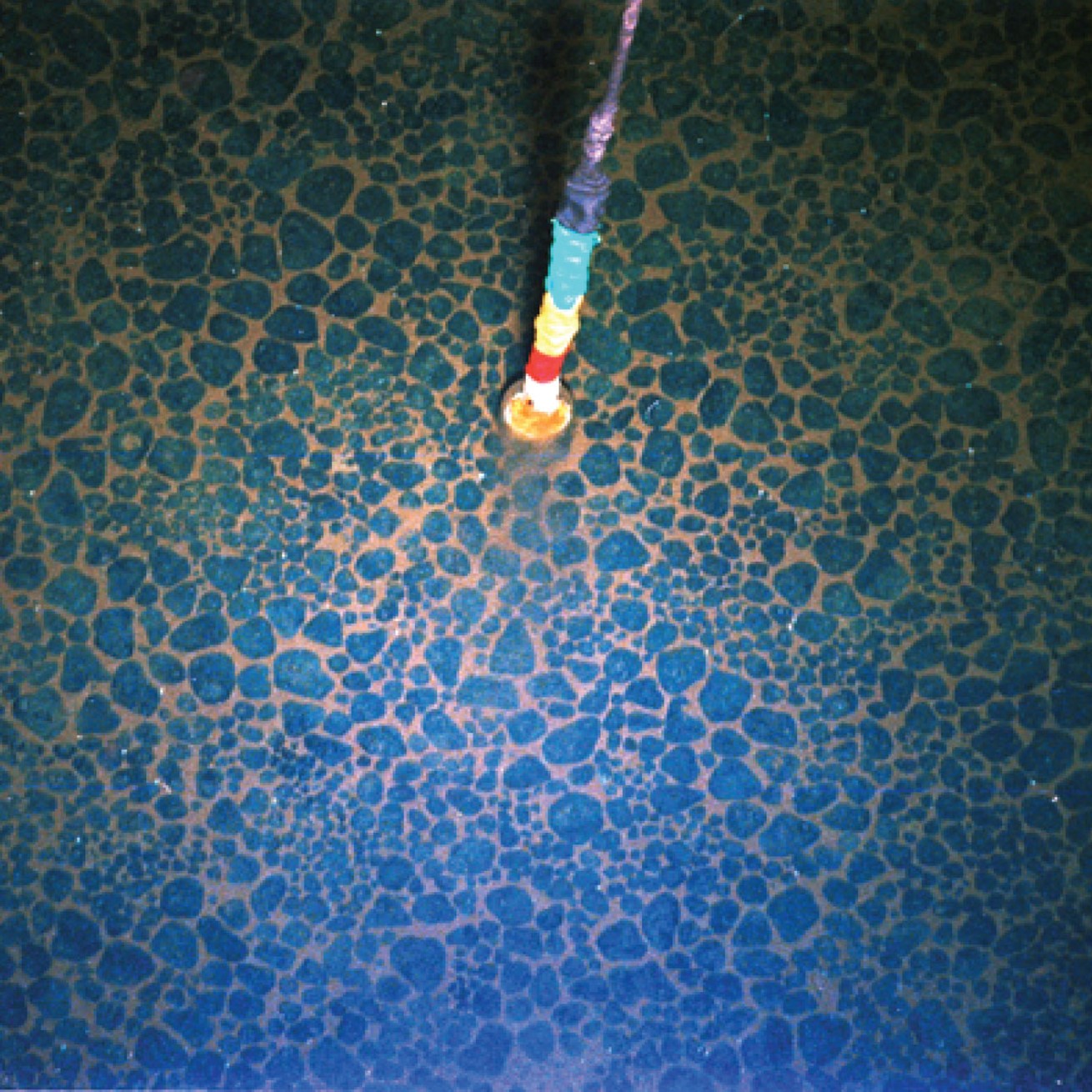
- The first deep-ocean polymetallic nodules were collected during the 1873 to 1876 expedition of the HMS Challenger, a Royal Navy vessel converted into a scientific research ship.
- The nodules were retrieved from the western edge of an area south of the Hawaiian Islands now known as the Clarion-Clipperton Zone (CCZ) in August of 1875 during deep-sea bathymetric soundings at depths ranging from 2.7 to 3.4 mi (4,300–5,500 m) below sea level.
2015 photo of ferromanganese nodules collected from the deep seafloor off the Cook Islands in the southwest Pacific Ocean. Alternating black-and-white squares are 0.4 inches (1 centimeter) on a side.
Credit: USGS - When opened, the nodules were found to contain nuclei consisting of sediment and rocks and sometimes even shark teeth and cetacean ear bones covered in concentric layers of iron (Fe) and manganese (Mn) oxides, which were enriched in metals including nickel and copper.
- After World War II and into the 1960’s, revived research interest in abyssal nodule samples, as well as crust samples from seamounts, revealed how the lumpy nodules and crusts were formed.
- The nodules were retrieved from the western edge of an area south of the Hawaiian Islands now known as the Clarion-Clipperton Zone (CCZ) in August of 1875 during deep-sea bathymetric soundings at depths ranging from 2.7 to 3.4 mi (4,300–5,500 m) below sea level.
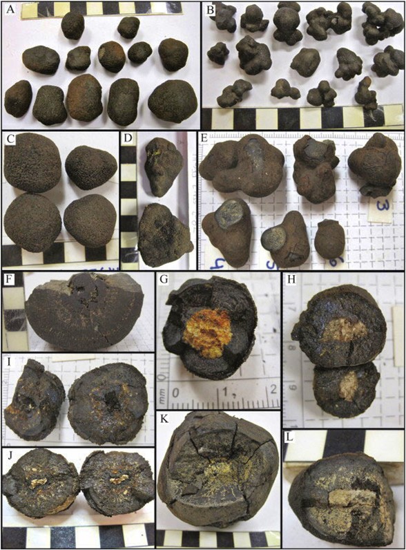
- Polymetallic nodules develop when iron and manganese, dissolved in both seawater and sediment pore water, are slowly oxidized, precipitating and accumulating ferromanganese (Fe, Mn) oxide particles around available nuclei at the dark, frigid abyssal sediment–water interface.
- Different metals, morphologies and textures occur in the exposed (hydrogenous) part of the nodule compared to the buried (diagenetic) part.
- Each nodule grows incredibly slowly growing at average rates of just 5 to 10 mm per million years.
- Constant flow of deep oxygenated bottom water currents to the nodule fields is important to clean away fine sediment and to maintain oxide precipitation.
- They are very porous with high internal surface area while their slightly negatively charged iron layers and positively charged manganese layers provide adsorption sites for trace elements. Cobalt, nickel, copper, molybdenum, titanium, lithium, rare earth elements and yttrium are some of the key elements of economic interest that concentrate in the nodules over millions of years.
- Huge fields of nodules form in areas with very low sedimentation rates, and some nodules may become buried in sediment if sedimentation rates increase.
- Manganese nodules have been studied in several areas:
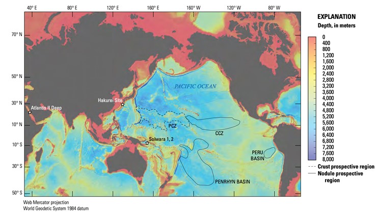
Map of major marine regions that are prospective, and of economic interest, for ferromanganese crusts (prime crust zone [PCZ]) and manganese nodules (CCZ), in the Peru Basin and Penrhyn Basin). Locations where marine mineral resource assessments have been conducted as of March 2021 are labeled with stars.
Credit: USGS- The CCZ is about the size of Europe, running from south of Hawaii toward the west coast of Mexico.
- The Peru Basin is about half the size of the CCZ, lying in the Pacific about 1,850 mi (3,000 m) west of the Peruvian coast.
- The Penrhyn Basin, a large portion of which is located within the Cook Islands in the southwestern Pacific, contains large nodule fields with high nodule abundance.
- In the Indian Ocean, a large, dense nodule field has been located in the Central Indian Ocean Basin.
- Nodule accumulations have also been noted in the Baltic Sea.
- Polymetallic crusts form from seawater precipitation of ferromanganese oxides on bare rock surfaces, creating pavements that record the history of ocean waters, some reaching as far back as 74 million years.
- They have been found in all of Earth’s oceans.
- Crusts form even more slowly than nodules at rates of about 1 to 5 mm per million years on elevated surfaces around oceanic seamounts and plateaus as shallow as 2,300 ft (700 m) deep.
- Their thicknesses ranges from a couple millimeters up to a maximum of about 12 in (30 cm).
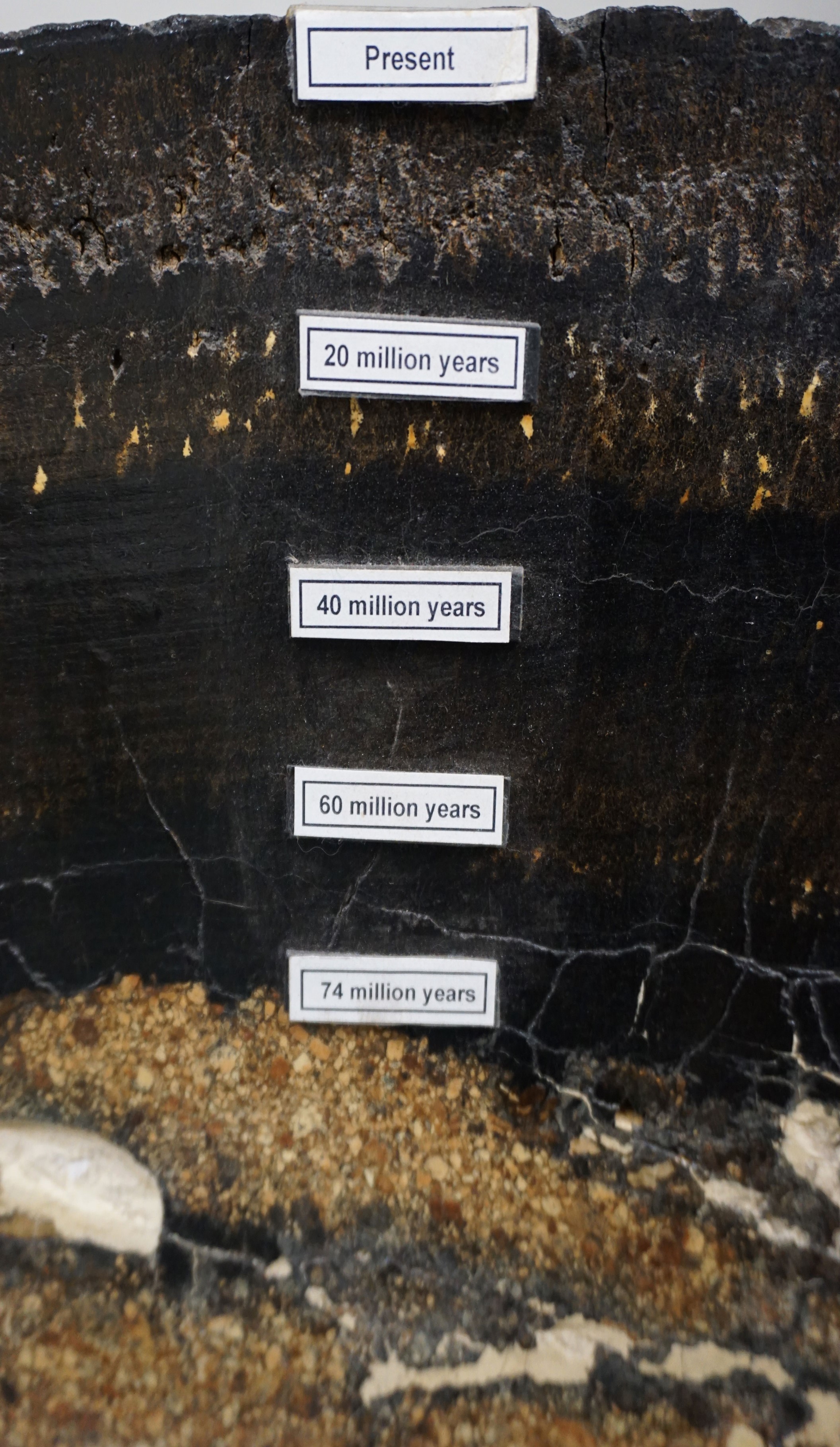
A cross section of one of the thickest ferromanganese crusts ever recovered, with the depositional ages labeled. Many textural layers reflect changes in oceanographic conditions over its 74-million-year growth. This crust sample was collected by dredge from the Marshall Islands at around a 6,560 feet (2,000 meter) depth during a USGS research expedition in 1989.
Credit: USGS - Like nodules, crusts also act like trace metal sponges, adsorbing metals of economic interest including cobalt, tellurium, nickel, copper, platinum and rare earth elements.
- But unlike potato shaped nodules that can be “vacuumed” to the surface for easy mining, crusts are difficult to separate from underlying rocks.
- (Crusts that form near hydrothermal vents are different and tend to be either manganese oxide or iron oxide instead of ferromanganese oxides. They grow much faster than those that form away from hydrothermal sources.)
- While human civilization is pressed for raw materials for batteries, computing and so-called “renewable” technologies like solar cells, scientists agree that mining the deep sea will impact this huge and still unknown ocean ecosystem. While there is no way to eliminate these concerns, researchers and engineers are working to collect data and develop technologies to provide the least harmful sustainable solutions.
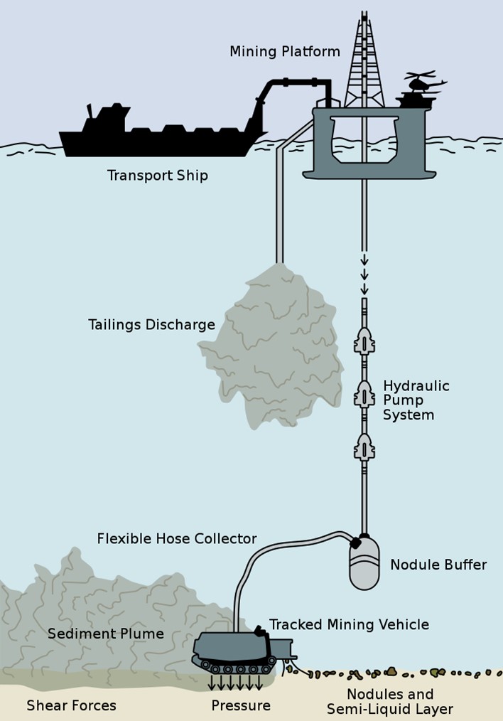
A schematic of manganese nodules mining on the deep seafloor. Environmental impacts are underlined.
Credit: MimiDeepSea, via Wikimedia Commons- Harvesting machines plowing across the seafloor would stir up sediment plumes that could kill delicate seafloor organisms cloaked by the sediment. Experiments show this has occurred as much as a mile (1,600 m) away. How long will it take the seafloor to heal?
- Slow moving and sessile creatures would be vacuumed into harvesters and killed by depressurization on the trip to the surface.
- Noise and vibrations from mining equipment may cause animals in the water column to desert their normal ranges.
- Ships cleaning nodules of sediment and removing excess water may release plumes higher in the water column that could have impacts to many sizes and types of biology inhabiting these mid-water depth ranges.
- Who can mine the ocean floor is dictated by proximity to land.
- Resources within 200 nautical miles of a country occur within the Exclusive Economic Zone (EEZ) of that country and exploitation regulations are set by that country. Many occurrences of polymetallic crusts occur on elevated features that fall into EEZs, managed by a single country.
- Outside of the EEZ, mining is regulated by the United Nations’ International Seabed Authority (ISA), profits from which are to be shared equitably. Many manganese nodule fields are in international waters, falling into ISA jurisdiction.
- By the start of 2022, 31 exploration licenses had been approved by the ISA, but no contracts for mining had been awarded.
- In July of 2021, the tiny island nation of Nauru triggered the “two-year rule” urging the ISA to finalize mining regulations and plans for equitable distribution of benefits by July of 2023. After that, mining contracts could be awarded, bound by the new regulations. The feasibility of meeting this deadline, and the exact interpretation of the trigger rule if regulations are not finalized, remain unknown.
- Many scientists and some nations, including Council Members at the ISA, have called for pauses or moratoriums because of concerns that not enough will be known about these ecosystems in 2023 to understand how to create regulations to protect them.
- Mining technology has been developed for polymetallic nodules, and experiments and equipment tests have been undertaken, while crust harvesting technology remains in the prototype stage.
- The ISA will require “environmentally sound exploitation” of these rich mineral resources, but exactly what that means is still being carefully discussed and decided. Many thorny issues remain.