Credit: NOAA
In 1769, Ben Franklin was the first to map the Gulf Stream. It’s Earth’s most famous current, moving more water than the Amazon River.
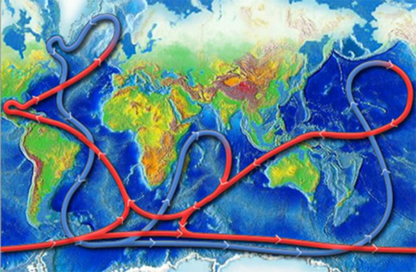
But the Gulf Stream is just one part of the global ocean conveyor, a system of currents that connects the world’s oceans.
In tropical seas, wind and tides drive warm surface currents, like the Gulf Stream.
Near the poles, cold air, evaporation, and ice formation make the seawater colder and saltier. It sinks to the bottom, and warm tropical water is pulled up to take its place.
In this way, the global ocean conveyor carries tropical heat toward the poles. And carries nutrient- and carbon-rich water from the poles to the tropics, where it feeds phytoplankton, the base of the world’s food web.
The conveyor’s stability over more than 10,000 years has helped regulate climate, weather, and fish populations, contributing to the rise of human civilization.
But since 1850, before the Industrial Age, the Gulf Stream has shown signs of slowing. It’s at its weakest in 1,000 years.
In 2009 and ’10, it moved a third less warm water than usual, causing colder winters in the Eastern U.S. and Europe.
Melting ice in the Arctic has been releasing freshwater onto the ocean surface, disrupting the flow of the cold, salty waters that drive the North Atlantic part of the ocean conveyor.
In this way, paradoxically, a warming climate can bring colder winters in the north.
Background
Synopsis: Ocean currents swirl from the surface to the depths of the “World Ocean” (the interconnected systems of Earth’s oceanic waters), impacting shipping and weather systems as well as mixing essential surface nutrients and oxygen into the deep waters to support marine life. The stability of this oceanic circulation has mediated our climate for millennia but recently has been weakening.
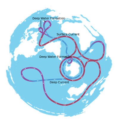
- Global ribbons of surface and deep ocean currents dive and rise in the waters making up the World Ocean, in a process known as the global ocean conveyor belt.
- This network of currents connects Earth’s five distinctive oceans: the Arctic (smallest, shallowest, and perhaps coldest), Atlantic (saltiest), Pacific (largest), Indian (warmest), and Southern (deepest and perhaps coldest).
- Because large parts of these currents run from pole to pole, similar to meridians (lines of longitude), this global ocean conveyor belt is also known in scientific circles as meridional overturning circulation (MOC).
- Ocean currents are “streams” of seawater that move continuously in a particular direction within the ocean. These currents impact heat and nutrient distribution, weather, and shipping.
- Surface ocean currents are driven by wind and tides in about the upper 100 m (328 ft) of seawater. One of the most famous surface currents in the global ocean conveyor belt is the Gulf Stream.
- The Gulf Stream is a wind-driven current that may run as far as a mile below the sea surface, funneling warm water northward along the east coast of North America toward Europe.
- The Gulf Stream is up to 150 miles (240 km) wide and moves more water than the Amazon River—up to 26 billion gallons of water a second—at speeds of about 5.6 mph (2.5 m/s).
- In 1769, Ben Franklin published the first map of the Gulf Stream for mariners.
- Deep ocean currents move hundreds of times slower than surface currents: just fractions of inches per second. Deep currents are driven by density differences, which depend on the water’s temperature and salinity, known as thermohaline circulation.
- Cold water is denser than warm water, so cold water sinks below warm water masses (thermo-).
- Saltwater is denser than freshwater, so freshwater floats above saltier bodies of water (-haline).
- When water masses sink or rise, an equal volume of water must move into the void to offset the change.
- Processes in the North Atlantic play a major role in driving the global ocean conveyor belt.
- Warm, salty waters of the Gulf Stream flow into the Labrador and Nordic Seas, releasing heat that warms Western Europe; for instance, London, with its temperature range of 40–75oF, is actually farther north than snowy Calgary, Canada, which has an annual temperature range of 8–75oF.
- Icy winds and low ambient temperatures in the Arctic Ocean drive evaporative cooling and freezing, both of which increase salinity by removing water molecules from seawater, leaving the salt behind.
- This cold, salty water sinks to the ocean bottom, and warmer surface water moves northward to fill the void. Then that water cools, evaporates, freezes, concentrating salt and sinking, and yet more surface water fills its void. Then the cycle continues, forming a downwelling current that is continuously driven by the sinking water.
- Similar to the way water flows across the land, when the dense North Atlantic Deep Water (NADW) reaches the ocean floor, it spills in slow motion through valleys in the bathymetry, hugging the seafloor as it eventually fills the basin of the Atlantic abyssal plain. The topography of the ocean floor constrains these dense water masses as they flow below normal seawater.
- The NADW mass can’t make it directly into the Pacific because the shallows of the Bering Strait block the cold dense water from leaving the Arctic Ocean by that route; instead, this water takes up to 1,000 years to slowly transit from the North Atlantic, around Antarctica, to the North Pacific.
- The Mid-Atlantic Ridge also limits the flow of the NADW as it slowly makes its way southward, approaching the tips of Africa and South America, and the Southern Ocean.
- More cold, salty bottom water recharges the global ocean conveyor belt in the Southern Ocean, where easterly currents flow at surface, intermediate, and deep levels.
- The Antarctic Circumpolar Current (ACC), which circles Antarctica, is Earth’s largest surface current system, linking the world oceans.
- The ACC flows clockwise at about 2.5 mph (4 km/h) from west to east, as its individual current jets meander and shift dramatically.
- It extends from the surface down to depths of 2.5 miles (4 km).
- Well-defined intermediate currents and deep currents circulate in the same direction below the ACC.
- The Southern Ocean is Earth’s deepest ocean; the Antarctic Bottom Water (AABW) that forms there is colder and saltier than the NADW arriving from the North Atlantic.
- Bottom topography forces the AABW to split into two streams: the AABW that forms in the Weddell Sea flows into the Atlantic and Indian Ocean basins, and the AABW that forms in the Ross Sea is destined for the Pacific Ocean basin.
- The denser AABW that flows northward slips beneath the NADW, filling ocean topography and tilting the NADW current up toward the surface. This phenomenon causes upwelling that brings deep-water nutrients to the upper ocean via cold-water currents.
- The AABW then continues its trek toward the equator, where it disperses and mixes with intermediate deep-water masses, then upwells when encountering sea-bottom topography. Eventually, these waters complete their circuit to the surface, where they join warm surface currents and move toward the poles to start the journey again.
- Earth’s MOC has benefited humankind for millennia.
- The constantly moving global conveyor distributes energy, in the form of heat, from the tropics to the poles and around the globe. Its long-term stability over more than 10,000 years has helped to regulate climate and weather patterns, contributing to the rise of global civilization.
- The MOC also distributes matter throughout the ocean. As ocean water travels along the conveyor, surface waters that are nutrient deprived and overly oxygenated pick up deep-water nutrients and carbon dioxide to support the base of the world’s food chain, essential to all other organisms, including humankind.
- Recent studies have shown that parts of the global ocean conveyor belt have been slowing since the 1850s.
- Warmer waters have been accumulating within the Gulf Stream, and cooler waters are pooling near Greenland, where cold glacial meltwater is accumulating.
- As glaciers and ice sheets melt, they release freshwater into the ocean that floats on the seawater, disrupting the evaporative cooling and ice formation that generates the dense, cold, salty seawater that plunges downward to drive the North Atlantic part of the global ocean conveyor belt.
- Using sediment records to track the strength of ocean currents, scientists have shown that the Gulf Stream is at its weakest since 1,600 years ago.
- This slowing of the global ocean conveyor belt has the potential to impact the exchange of heat between the tropics and the poles, as well as overall global weather patterns.
- Between 2009 and 2010, the Gulf Stream moved only two-thirds of the volume of water it usually carries. Winters along the East Coast of the U.S. and western Europe were colder than usual during those years. Could this be a trend?
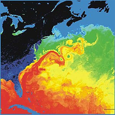
Surface temperatures in the western North Atlantic. The North American landmass is black and dark blue (cold), while the Gulf Stream is red (warm).
Credit: NASA